
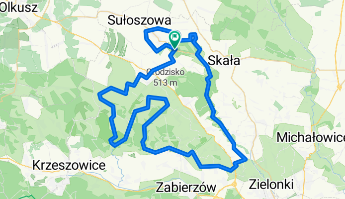
park ojcowski - dolina będkowska
A cycling route starting in Sąspów, Lesser Poland Voivodeship, Poland.
Overview
About this route
- -:--
- Duration
- 76.8 km
- Distance
- 652 m
- Ascent
- 638 m
- Descent
- ---
- Avg. speed
- ---
- Max. altitude
Route quality
Waytypes & surfaces along the route
Waytypes
Quiet road
34.5 km
(45 %)
Road
20.6 km
(27 %)
Surfaces
Paved
60.1 km
(78 %)
Unpaved
14.8 km
(19 %)
Asphalt
57.6 km
(75 %)
Ground
8.2 km
(11 %)
Continue with Bikemap
Use, edit, or download this cycling route
You would like to ride park ojcowski - dolina będkowska or customize it for your own trip? Here is what you can do with this Bikemap route:
Free features
- Save this route as favorite or in collections
- Copy & plan your own version of this route
- Sync your route with Garmin or Wahoo
Premium features
Free trial for 3 days, or one-time payment. More about Bikemap Premium.
- Navigate this route on iOS & Android
- Export a GPX / KML file of this route
- Create your custom printout (try it for free)
- Download this route for offline navigation
Discover more Premium features.
Get Bikemap PremiumFrom our community
Other popular routes starting in Sąspów
 ojców
ojców- Distance
- 50.3 km
- Ascent
- 986 m
- Descent
- 986 m
- Location
- Sąspów, Lesser Poland Voivodeship, Poland
 Skarbami Jury Krakowsko-Częstochowskiej
- Distance
- 46.7 km
- Ascent
- 587 m
- Descent
- 581 m
- Location
- Sąspów, Lesser Poland Voivodeship, Poland
 Weekend na jurze część 2/2
- Distance
- 279.4 km
- Ascent
- 646 m
- Descent
- 907 m
- Location
- Sąspów, Lesser Poland Voivodeship, Poland
 park ojcowski - dolina będkowska
- Distance
- 76.8 km
- Ascent
- 652 m
- Descent
- 638 m
- Location
- Sąspów, Lesser Poland Voivodeship, Poland
 Piesza 4 - Ojcowski Park Narodowy
- Distance
- 21.8 km
- Ascent
- 507 m
- Descent
- 608 m
- Location
- Sąspów, Lesser Poland Voivodeship, Poland
 Ojcowska 81, Wola Kalinowska do Ojcowska 81, Wola Kalinowska
- Distance
- 28.2 km
- Ascent
- 634 m
- Descent
- 634 m
- Location
- Sąspów, Lesser Poland Voivodeship, Poland
 Droga Gminna do 297, Wielmoża
- Distance
- 11.9 km
- Ascent
- 156 m
- Descent
- 169 m
- Location
- Sąspów, Lesser Poland Voivodeship, Poland
 Sąspów
- Distance
- 22.8 km
- Ascent
- 342 m
- Descent
- 342 m
- Location
- Sąspów, Lesser Poland Voivodeship, Poland
Open it in the app