

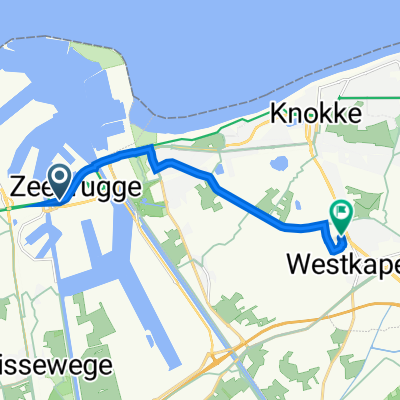
Hull-Zebrugge ferry terminal to Bxl route
A cycling route starting in Zeebrugge, Flemish Region, Belgium.
Overview
About this route
bike path around Zebrugge to canalside path south
- -:--
- Duration
- 5.6 km
- Distance
- 13 m
- Ascent
- 17 m
- Descent
- ---
- Avg. speed
- ---
- Max. altitude

Route quality
Waytypes & surfaces along the route
Waytypes
Cycleway
4.1 km
(74 %)
Quiet road
0.6 km
(11 %)
Surfaces
Paved
3.8 km
(68 %)
Unpaved
0.1 km
(1 %)
Asphalt
1.9 km
(34 %)
Concrete
1.8 km
(33 %)
Route highlights
Points of interest along the route

Point of interest after 3.8 km
Bakery
Continue with Bikemap
Use, edit, or download this cycling route
You would like to ride Hull-Zebrugge ferry terminal to Bxl route or customize it for your own trip? Here is what you can do with this Bikemap route:
Free features
- Save this route as favorite or in collections
- Copy & plan your own version of this route
- Sync your route with Garmin or Wahoo
Premium features
Free trial for 3 days, or one-time payment. More about Bikemap Premium.
- Navigate this route on iOS & Android
- Export a GPX / KML file of this route
- Create your custom printout (try it for free)
- Download this route for offline navigation
Discover more Premium features.
Get Bikemap PremiumFrom our community
Other popular routes starting in Zeebrugge
 Grote Prijs van de West-Vlaamse Betonkust
- Distance
- 102.8 km
- Ascent
- 83 m
- Descent
- 80 m
- Location
- Zeebrugge, Flemish Region, Belgium
 Hull-Zeebrugge ferry to Zeebrugge-Dorp starion
- Distance
- 3.1 km
- Ascent
- 13 m
- Descent
- 13 m
- Location
- Zeebrugge, Flemish Region, Belgium
 fietsnet
- Distance
- 32.7 km
- Ascent
- 14 m
- Descent
- 16 m
- Location
- Zeebrugge, Flemish Region, Belgium
 Kustlaan 97, Bruges to 't Walletje, Knokke-Heist
- Distance
- 9.7 km
- Ascent
- 60 m
- Descent
- 65 m
- Location
- Zeebrugge, Flemish Region, Belgium
 fietsnet
- Distance
- 48.5 km
- Ascent
- 35 m
- Descent
- 37 m
- Location
- Zeebrugge, Flemish Region, Belgium
 Kustlaan 97, Bruges to 't Walletje, Knokke-Heist
- Distance
- 8.7 km
- Ascent
- 7 m
- Descent
- 10 m
- Location
- Zeebrugge, Flemish Region, Belgium
 SuEurope
- Distance
- 5,675.8 km
- Ascent
- 4,546 m
- Descent
- 3,853 m
- Location
- Zeebrugge, Flemish Region, Belgium
 Kustlaan 97, Bruges to 't Walletje, Knokke-Heist
- Distance
- 8.3 km
- Ascent
- 13 m
- Descent
- 20 m
- Location
- Zeebrugge, Flemish Region, Belgium
Open it in the app