
VM-RPH-V
- 62.7 km
- 1,140 m
- 1,141 m
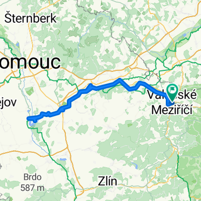
- Valašské Meziříčí, Zlín, Czechia
A cycling route starting in Valašské Meziříčí, Zlín, Czechia.
Overview
Autor: Karolína Machů
The route from Valašské Meziříčí to Rožnov to Bečvy is very popular as it is comfortable. It is about thirty kilometers long, with a drop of 255 meters in elevation. The route is therefore easy. Almost its entire length has an asphalt surface.
When starting from Valašské Meziříčí, you can also take a break there. It is a city with a rich history, and you can visit, for example, the house U Dvanácti apoštolů (49.4715022N, 17.9692083E), which is significant due to the sculpted reliefs that decorate it. These are from the turn of the 17th and 18th centuries and depict apostolic motifs.
Further along, the cycle path will take you to Hrachovec, a municipality known for its popular bakery and pastry shop. On the way, you can enjoy a traditional Valašský frgál.
Before entering the town of Zubří, you will pass a rest area by the weir (49.4603508N, 18.0712000E). It is a beautiful spot for a moment's rest on the benches. You can refresh yourself, drink something, and regain your strength for the next part of the journey. After passing through the town of Zubří, you will arrive in Rožnov pod Radhoštěm.
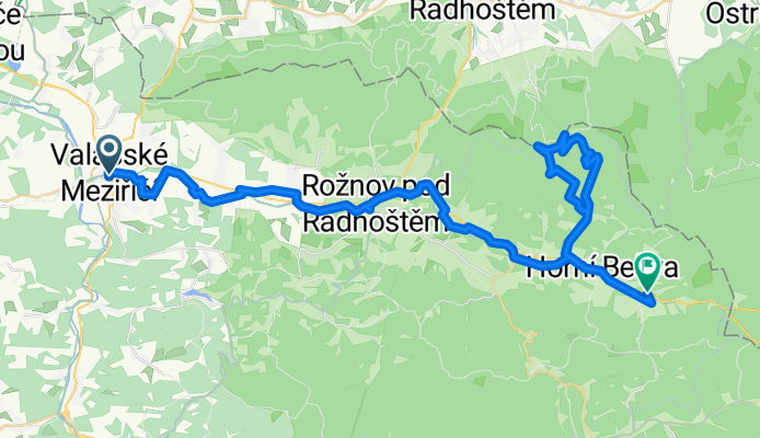
This town is especially famous for the Valašské Museum in Nature (49.4622042N, 18.1486631E). It is definitely worth a visit, as it is the oldest open-air museum in Central Europe. Regularly, several events are hosted here, and with a bit of luck, you may even run into one of them. Folklore and craft events are held. Near the museum, you will find the Jurkovič Observation Tower, from which you can view the beautiful surroundings.
Due to tourist demand, the accommodation and dining options in the town are high, and it is not difficult to enjoy good food at almost every corner. However, an interesting feature of the town is also the beer baths that you can enjoy at the Rožnov beer baths, providing you with an unforgettable experience.
Continuing along the route, you will pass through Valašská Bystřice and Pustevny before you find yourself in Dolní and then Horní Bečva. If you decide to visit Pustevny (Pustevny 49.4891725N, 18.2670917E), prepare for a more challenging climb from the cycle path itself. The road to Pustevny is about ten kilometers long, and you will face an ascent of 630 meters. However, your reward will be the viewpoint Cyrilka (49.4849844N, 18.2612822E), which is a national cultural monument, or the mountain Radhošť (49.4915864N, 18.2231200E).
However, if you decide to stay in Bečva, your route will be easy and relaxing. Horní Bečva is primarily known as a recreation area that can be visited in both summer and winter. The biggest summer attraction is the local dam (49.4216914N, 18.3164994E), where you can enjoy tranquility after completing the entire route.
created this 6 years ago
Route quality
Road
15.2 km
26 %
Cycleway
15.2 km
26 %
Paved
29.9 km
(51 %)
Unpaved
2.9 km
(5 %)
Asphalt
26.9 km
46 %
Paved (undefined)
2.9 km
5 %
Continue with Bikemap
You would like to ride CYKLOSTEZKA: Valašské Meziříčí – Rožnov – Bečvy or customize it for your own trip? Here is what you can do with this Bikemap route:
Free trial for 3 days, or one-time payment. More about Bikemap Premium.
Discover more Premium features.
Get Bikemap PremiumFrom our community
Open it in the app