

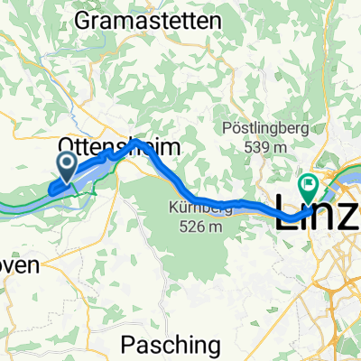
RV to Downtown Linz
A cycling route starting in Ottensheim, Upper Austria, Austria.
Overview
About this route
From Campground in Hoflein along North Shore of Danube to Downtown Linz
- -:--
- Duration
- 12.9 km
- Distance
- 87 m
- Ascent
- 79 m
- Descent
- ---
- Avg. speed
- ---
- Max. altitude

Route quality
Waytypes & surfaces along the route
Waytypes
Cycleway
6.7 km
(52 %)
Quiet road
3.6 km
(28 %)
Surfaces
Paved
11.8 km
(91 %)
Asphalt
11.3 km
(87 %)
Paved (undefined)
0.3 km
(2 %)
Continue with Bikemap
Use, edit, or download this cycling route
You would like to ride RV to Downtown Linz or customize it for your own trip? Here is what you can do with this Bikemap route:
Free features
- Save this route as favorite or in collections
- Copy & plan your own version of this route
- Sync your route with Garmin or Wahoo
Premium features
Free trial for 3 days, or one-time payment. More about Bikemap Premium.
- Navigate this route on iOS & Android
- Export a GPX / KML file of this route
- Create your custom printout (try it for free)
- Download this route for offline navigation
Discover more Premium features.
Get Bikemap PremiumFrom our community
Other popular routes starting in Ottensheim
 Von Aigen-Schlägl bis Ottensheim
- Distance
- 51.4 km
- Ascent
- 1,237 m
- Descent
- 900 m
- Location
- Ottensheim, Upper Austria, Austria
 Wilhering bis Linz
- Distance
- 15.1 km
- Ascent
- 42 m
- Descent
- 43 m
- Location
- Ottensheim, Upper Austria, Austria
 Ottensheim nach Perg Hauptplatz
- Distance
- 47.2 km
- Ascent
- 75 m
- Descent
- 103 m
- Location
- Ottensheim, Upper Austria, Austria
 erste mühlviertel-runde-jahr1993
- Distance
- 45.4 km
- Ascent
- 920 m
- Descent
- 914 m
- Location
- Ottensheim, Upper Austria, Austria
 EidenbergerAlm Rundkurs
- Distance
- 28.6 km
- Ascent
- 747 m
- Descent
- 744 m
- Location
- Ottensheim, Upper Austria, Austria
 Ottensheim - Bad Kreuzen
- Distance
- 71.6 km
- Ascent
- 271 m
- Descent
- 299 m
- Location
- Ottensheim, Upper Austria, Austria
 Ottensheim - Bad Kreuzen
- Distance
- 65.8 km
- Ascent
- 21 m
- Descent
- 58 m
- Location
- Ottensheim, Upper Austria, Austria
 GIS - Variante
- Distance
- 59.8 km
- Ascent
- 1,052 m
- Descent
- 1,053 m
- Location
- Ottensheim, Upper Austria, Austria
Open it in the app