4:Ronda-Pto Palomas-Setenil
A cycling route starting in Ronda, Andalusia, Spain.
Overview
About this route
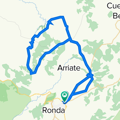
Ronda-Benacan-Montejaque-Grazalema-pto Palomas-Zahara del SierraAlgodonales-Setenil de las Bodegas-Ronda
- -:--
- Duration
- 108.4 km
- Distance
- 2,409 m
- Ascent
- 2,405 m
- Descent
- ---
- Avg. speed
- ---
- Max. altitude
Route quality
Waytypes & surfaces along the route
Waytypes
Road
81.3 km
(75 %)
Quiet road
1.1 km
(1 %)
Undefined
26 km
(24 %)
Surfaces
Paved
54.2 km
(50 %)
Asphalt
54.2 km
(50 %)
Undefined
54.2 km
(50 %)
Continue with Bikemap
Use, edit, or download this cycling route
You would like to ride 4:Ronda-Pto Palomas-Setenil or customize it for your own trip? Here is what you can do with this Bikemap route:
Free features
- Save this route as favorite or in collections
- Copy & plan your own version of this route
- Split it into stages to create a multi-day tour
- Sync your route with Garmin or Wahoo
Premium features
Free trial for 3 days, or one-time payment. More about Bikemap Premium.
- Navigate this route on iOS & Android
- Export a GPX / KML file of this route
- Create your custom printout (try it for free)
- Download this route for offline navigation
Discover more Premium features.
Get Bikemap PremiumFrom our community
Other popular routes starting in Ronda
Etappe 3: van Ronda naar Utrera- Distance
- 98 km
- Ascent
- 1,789 m
- Descent
- 2,444 m
- Location
- Ronda, Andalusia, Spain
Day5 -Setenil loop- Distance
- 48.6 km
- Ascent
- 1,541 m
- Descent
- 1,539 m
- Location
- Ronda, Andalusia, Spain
Ronda Loop- Distance
- 57.6 km
- Ascent
- 1,164 m
- Descent
- 1,163 m
- Location
- Ronda, Andalusia, Spain
101km de Ronda ed.2011 -www.zonaciclista.com- Distance
- 100.9 km
- Ascent
- 1,596 m
- Descent
- 1,579 m
- Location
- Ronda, Andalusia, Spain
Sierra Hidalga- Distance
- 26.2 km
- Ascent
- 898 m
- Descent
- 943 m
- Location
- Ronda, Andalusia, Spain
Ronda la Vieja, Setenil, Parchite- Distance
- 53.6 km
- Ascent
- 717 m
- Descent
- 717 m
- Location
- Ronda, Andalusia, Spain
J2 - Transandalousie (88km 1520D+)- Distance
- 88 km
- Ascent
- 1,027 m
- Descent
- 1,254 m
- Location
- Ronda, Andalusia, Spain
Ruta Setenil- Distance
- 46.3 km
- Ascent
- 508 m
- Descent
- 501 m
- Location
- Ronda, Andalusia, Spain
Open it in the app

