Akátová věž
A cycling route starting in Rajhradice, South Moravian, Czechia.
Overview
About this route
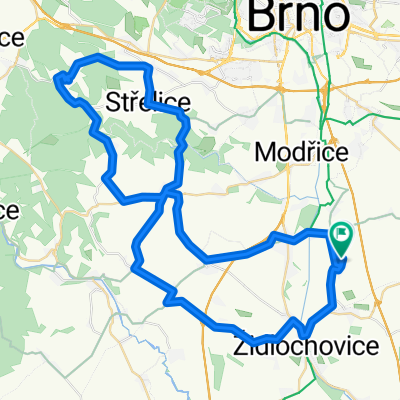
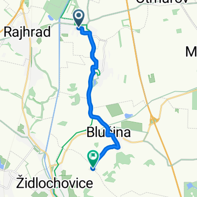
Večerní výlet na Akátovou věž na Výhoně + nějaké ty kilometry na rovinném kolečku.
Na Akátovou věž lze pohodlněji dojet z druhé strany z Blučiny po silnici. Já se vydal polní cestou z Židlochovic.
- -:--
- Duration
- 41.3 km
- Distance
- 191 m
- Ascent
- 191 m
- Descent
- ---
- Avg. speed
- ---
- Avg. speed
Route quality
Waytypes & surfaces along the route
Waytypes
Busy road
13.8 km
(33 %)
Road
10.9 km
(26 %)
Surfaces
Paved
27 km
(65 %)
Unpaved
2.3 km
(6 %)
Asphalt
25.9 km
(63 %)
Unpaved (undefined)
2 km
(5 %)
Continue with Bikemap
Use, edit, or download this cycling route
You would like to ride Akátová věž or customize it for your own trip? Here is what you can do with this Bikemap route:
Free features
- Save this route as favorite or in collections
- Copy & plan your own version of this route
- Sync your route with Garmin or Wahoo
Premium features
Free trial for 3 days, or one-time payment. More about Bikemap Premium.
- Navigate this route on iOS & Android
- Export a GPX / KML file of this route
- Create your custom printout (try it for free)
- Download this route for offline navigation
Discover more Premium features.
Get Bikemap PremiumFrom our community
Other popular routes starting in Rajhradice
- Rebešovice - Peregrin
- Distance
- 27.2 km
- Ascent
- 309 m
- Descent
- 314 m
- Location
- Rajhradice, South Moravian, Czechia
- mariánské údolí z Rajhradic
- Distance
- 65.8 km
- Ascent
- 768 m
- Descent
- 767 m
- Location
- Rajhradice, South Moravian, Czechia
- zkóška
- Distance
- 199.8 km
- Ascent
- 819 m
- Descent
- 820 m
- Location
- Rajhradice, South Moravian, Czechia
- Akátová věž
- Distance
- 41.3 km
- Ascent
- 191 m
- Descent
- 191 m
- Location
- Rajhradice, South Moravian, Czechia
- test of Strava GranFondo
- Distance
- 104.6 km
- Ascent
- 720 m
- Descent
- 720 m
- Location
- Rajhradice, South Moravian, Czechia
- cesta na brigádu
- Distance
- 28.3 km
- Ascent
- 355 m
- Descent
- 233 m
- Location
- Rajhradice, South Moravian, Czechia
- Rebešovice - přehrada
- Distance
- 39.5 km
- Ascent
- 434 m
- Descent
- 390 m
- Location
- Rajhradice, South Moravian, Czechia
- nedělní švihačka
- Distance
- 104.5 km
- Ascent
- 270 m
- Descent
- 269 m
- Location
- Rajhradice, South Moravian, Czechia
Open it in the app