
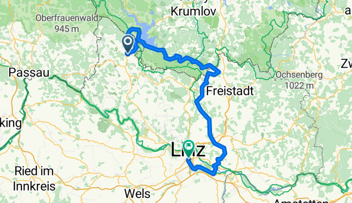
Aigen Schlägel - Lipno - Linz
A cycling route starting in Aigen im Mühlkreis, Upper Austria, Austria.
Overview
About this route
By train to AIGEN SCHLÄGEL.
From AIGEN SCHLÄGEL along the reservoir (stopping there for a coffee) and down to LINZ.
- -:--
- Duration
- 144.3 km
- Distance
- 781 m
- Ascent
- 1,078 m
- Descent
- ---
- Avg. speed
- ---
- Max. altitude

Route quality
Waytypes & surfaces along the route
Waytypes
Road
59.1 km
(41 %)
Quiet road
50.5 km
(35 %)
Surfaces
Paved
101 km
(70 %)
Unpaved
15.9 km
(11 %)
Asphalt
96.7 km
(67 %)
Gravel
13 km
(9 %)
Continue with Bikemap
Use, edit, or download this cycling route
You would like to ride Aigen Schlägel - Lipno - Linz or customize it for your own trip? Here is what you can do with this Bikemap route:
Free features
- Save this route as favorite or in collections
- Copy & plan your own version of this route
- Split it into stages to create a multi-day tour
- Sync your route with Garmin or Wahoo
Premium features
Free trial for 3 days, or one-time payment. More about Bikemap Premium.
- Navigate this route on iOS & Android
- Export a GPX / KML file of this route
- Create your custom printout (try it for free)
- Download this route for offline navigation
Discover more Premium features.
Get Bikemap PremiumFrom our community
Other popular routes starting in Aigen im Mühlkreis
 Moldaustauseerunde
- Distance
- 41.5 km
- Ascent
- 693 m
- Descent
- 695 m
- Location
- Aigen im Mühlkreis, Upper Austria, Austria
 Böhmerwald -Tour
- Distance
- 69.5 km
- Ascent
- 532 m
- Descent
- 531 m
- Location
- Aigen im Mühlkreis, Upper Austria, Austria
 802 Sonnenwald
- Distance
- 24.2 km
- Ascent
- 330 m
- Descent
- 331 m
- Location
- Aigen im Mühlkreis, Upper Austria, Austria
 Aigen - Kirchbach - St. Wolfgang - Aigen
- Distance
- 15.7 km
- Ascent
- 427 m
- Descent
- 430 m
- Location
- Aigen im Mühlkreis, Upper Austria, Austria
 Krakau Heimweg 6
- Distance
- 185.3 km
- Ascent
- 6,498 m
- Descent
- 6,691 m
- Location
- Aigen im Mühlkreis, Upper Austria, Austria
 RCR: Frühjahrstour 18 II MTB
- Distance
- 115.5 km
- Ascent
- 892 m
- Descent
- 1,404 m
- Location
- Aigen im Mühlkreis, Upper Austria, Austria
 Aigen - Plöckenstein - Aigen
- Distance
- 51.3 km
- Ascent
- 1,001 m
- Descent
- 1,001 m
- Location
- Aigen im Mühlkreis, Upper Austria, Austria
 Aigen - St. Thomas - Lipno
- Distance
- 60.6 km
- Ascent
- 676 m
- Descent
- 676 m
- Location
- Aigen im Mühlkreis, Upper Austria, Austria
Open it in the app