

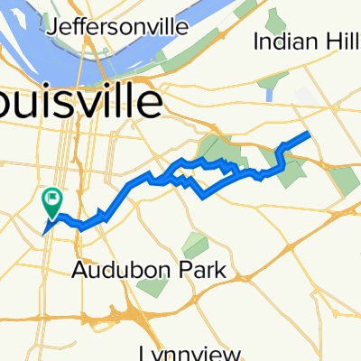
Restful route in Louisville
A cycling route starting in Audubon Park, Kentucky, United States.
Overview
About this route
- 29 min
- Duration
- 9.3 km
- Distance
- 110 m
- Ascent
- 100 m
- Descent
- 19.3 km/h
- Avg. speed
- ---
- Max. altitude

Route quality
Waytypes & surfaces along the route
Waytypes
Quiet road
9.1 km
(98 %)
Access road
0.1 km
(1 %)
Undefined
0.1 km
(1 %)
Surfaces
Paved
1.8 km
(19 %)
Paved (undefined)
1.8 km
(19 %)
Undefined
7.5 km
(81 %)
Continue with Bikemap
Use, edit, or download this cycling route
You would like to ride Restful route in Louisville or customize it for your own trip? Here is what you can do with this Bikemap route:
Free features
- Save this route as favorite or in collections
- Copy & plan your own version of this route
- Sync your route with Garmin or Wahoo
Premium features
Free trial for 3 days, or one-time payment. More about Bikemap Premium.
- Navigate this route on iOS & Android
- Export a GPX / KML file of this route
- Create your custom printout (try it for free)
- Download this route for offline navigation
Discover more Premium features.
Get Bikemap PremiumFrom our community
Other popular routes starting in Audubon Park
 Restful route in Louisville
- Distance
- 9.3 km
- Ascent
- 110 m
- Descent
- 100 m
- Location
- Audubon Park, Kentucky, United States
 U of L to Seneca Park and back
- Distance
- 25.5 km
- Ascent
- 110 m
- Descent
- 112 m
- Location
- Audubon Park, Kentucky, United States
 Easy ride in Louisville
- Distance
- 13.7 km
- Ascent
- 52 m
- Descent
- 48 m
- Location
- Audubon Park, Kentucky, United States
 to uk
to uk- Distance
- 134.3 km
- Ascent
- 500 m
- Descent
- 342 m
- Location
- Audubon Park, Kentucky, United States
 Cherokee to End of Louisville Loop
- Distance
- 47.6 km
- Ascent
- 56 m
- Descent
- 86 m
- Location
- Audubon Park, Kentucky, United States
 2511 Fleet Ave, Louisville to 2003 Winston Ave, Louisville
- Distance
- 6.5 km
- Ascent
- 71 m
- Descent
- 58 m
- Location
- Audubon Park, Kentucky, United States
 1529 Goddard Ave, Louisville to 1907 Bardstown Rd, Louisville
- Distance
- 2.9 km
- Ascent
- 12 m
- Descent
- 6 m
- Location
- Audubon Park, Kentucky, United States
 socialist bikr ride
- Distance
- 16.1 km
- Ascent
- 44 m
- Descent
- 43 m
- Location
- Audubon Park, Kentucky, United States
Open it in the app