

Zur Hundwiler Höhi
A cycling route starting in Gonten, Appenzell Innerrhoden, Switzerland.
Overview
About this route
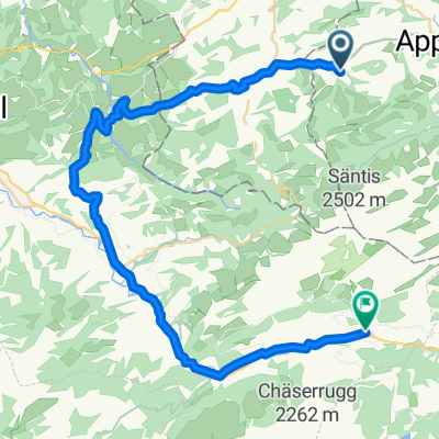
von Jacobsbad Richtung Urnäsch; im Urnäschtal Richtung Zürchersmühle, Abzweig Hundwil, Abzweig Hundwiler Höhi. Dann über Hundwil und Waldstatt zurück.
- -:--
- Duration
- 26.7 km
- Distance
- 391 m
- Ascent
- 389 m
- Descent
- ---
- Avg. speed
- ---
- Max. altitude

Route quality
Waytypes & surfaces along the route
Waytypes
Busy road
10.4 km
(39 %)
Road
7.7 km
(29 %)
Surfaces
Paved
12.9 km
(48 %)
Asphalt
11.9 km
(45 %)
Paved (undefined)
1 km
(4 %)
Undefined
13.8 km
(52 %)
Continue with Bikemap
Use, edit, or download this cycling route
You would like to ride Zur Hundwiler Höhi or customize it for your own trip? Here is what you can do with this Bikemap route:
Free features
- Save this route as favorite or in collections
- Copy & plan your own version of this route
- Sync your route with Garmin or Wahoo
Premium features
Free trial for 3 days, or one-time payment. More about Bikemap Premium.
- Navigate this route on iOS & Android
- Export a GPX / KML file of this route
- Create your custom printout (try it for free)
- Download this route for offline navigation
Discover more Premium features.
Get Bikemap PremiumFrom our community
Other popular routes starting in Gonten
 Route 1
- Distance
- 21.8 km
- Ascent
- 273 m
- Descent
- 274 m
- Location
- Gonten, Appenzell Innerrhoden, Switzerland
 Aufnahme vom 30. Dezember 11:41
- Distance
- 40.3 km
- Ascent
- 745 m
- Descent
- 662 m
- Location
- Gonten, Appenzell Innerrhoden, Switzerland
 Gerade Fahrt in Gonten
- Distance
- 32.2 km
- Ascent
- 1,339 m
- Descent
- 1,357 m
- Location
- Gonten, Appenzell Innerrhoden, Switzerland
 Laufteggstrasse 1, Jakobsbad nach Dorf 10, Wildhaus
- Distance
- 42.5 km
- Ascent
- 1,158 m
- Descent
- 951 m
- Location
- Gonten, Appenzell Innerrhoden, Switzerland
 Jakobsb_Igis
- Distance
- 76.6 km
- Ascent
- 914 m
- Descent
- 1,243 m
- Location
- Gonten, Appenzell Innerrhoden, Switzerland
 Barfussweg bei Regenwetter
- Distance
- 26.5 km
- Ascent
- 271 m
- Descent
- 691 m
- Location
- Gonten, Appenzell Innerrhoden, Switzerland
 Kaustrasse 1, Gontenbad nach Gemeindehausplatz 5, Glarus
- Distance
- 68.8 km
- Ascent
- 961 m
- Descent
- 1,399 m
- Location
- Gonten, Appenzell Innerrhoden, Switzerland
 Rund um den Kronberg 40 km 1450 hm
- Distance
- 40.8 km
- Ascent
- 1,418 m
- Descent
- 1,418 m
- Location
- Gonten, Appenzell Innerrhoden, Switzerland
Open it in the app