

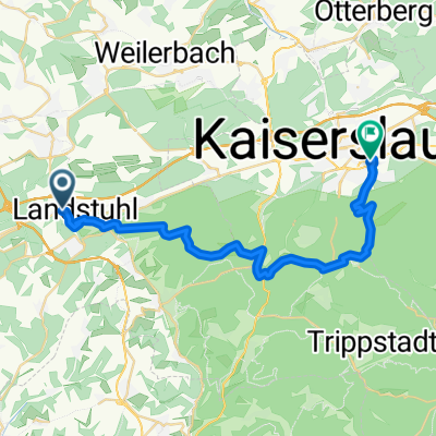
Air-Base Rundtour
A cycling route starting in Landstuhl, Rhineland-Palatinate, Germany.
Overview
About this route
Circular tour around the air base starting at Landstuhl train station --> good train connections. Whether all paths can be ridden without issues is still being researched
- -:--
- Duration
- 39.9 km
- Distance
- 157 m
- Ascent
- 154 m
- Descent
- ---
- Avg. speed
- ---
- Max. altitude
Route quality
Waytypes & surfaces along the route
Waytypes
Track
22.4 km
(56 %)
Quiet road
8.8 km
(22 %)
Surfaces
Paved
17.2 km
(43 %)
Unpaved
19.6 km
(49 %)
Asphalt
14.4 km
(36 %)
Gravel
11.6 km
(29 %)
Continue with Bikemap
Use, edit, or download this cycling route
You would like to ride Air-Base Rundtour or customize it for your own trip? Here is what you can do with this Bikemap route:
Free features
- Save this route as favorite or in collections
- Copy & plan your own version of this route
- Sync your route with Garmin or Wahoo
Premium features
Free trial for 3 days, or one-time payment. More about Bikemap Premium.
- Navigate this route on iOS & Android
- Export a GPX / KML file of this route
- Create your custom printout (try it for free)
- Download this route for offline navigation
Discover more Premium features.
Get Bikemap PremiumFrom our community
Other popular routes starting in Landstuhl
 Rund um die Täler
- Distance
- 27.4 km
- Ascent
- 376 m
- Descent
- 386 m
- Location
- Landstuhl, Rhineland-Palatinate, Germany
 Landstuhl-Beeden
- Distance
- 52.6 km
- Ascent
- 358 m
- Descent
- 372 m
- Location
- Landstuhl, Rhineland-Palatinate, Germany
 Radsport Wolf Permanente 2010 - 75 km Perm. des RSC 1950 Kaiserslautern e.V.
- Distance
- 73.9 km
- Ascent
- 528 m
- Descent
- 528 m
- Location
- Landstuhl, Rhineland-Palatinate, Germany
 Landstuhl to Weselberg
- Distance
- 27.1 km
- Ascent
- 278 m
- Descent
- 278 m
- Location
- Landstuhl, Rhineland-Palatinate, Germany
 Landstuhl Ride 1
- Distance
- 33.9 km
- Ascent
- 304 m
- Descent
- 305 m
- Location
- Landstuhl, Rhineland-Palatinate, Germany
 130825 DIaRad 2013 Tag 2
- Distance
- 57.7 km
- Ascent
- 171 m
- Descent
- 185 m
- Location
- Landstuhl, Rhineland-Palatinate, Germany
 Landstuhl-Gelterswoog
- Distance
- 13.5 km
- Ascent
- 277 m
- Descent
- 222 m
- Location
- Landstuhl, Rhineland-Palatinate, Germany
 Olsbrücken Sportplatz und zurück
- Distance
- 49.6 km
- Ascent
- 190 m
- Descent
- 190 m
- Location
- Landstuhl, Rhineland-Palatinate, Germany
Open it in the app