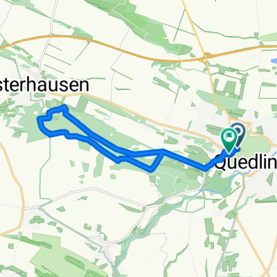
Harz-Rundfahrt
- 234.7 km
- 1,641 m
- 1,649 m
- Quedlinburg, Saxony-Anhalt, Germany
A cycling route starting in Quedlinburg, Saxony-Anhalt, Germany.
Overview
For advanced beginners or just to let your soul unwind. The climb to Altenburg is a perfect warm-up, as the slope is about 30°. Once at the top (please stay seated), head towards the lily pond. You'll pass idyllic paths. But beware: the trails have many tree roots and some steep downhills, so you'll get shaken up. After about 7 km you reach the descent. Caution: the Altenburg descent towards Westerhausen is just as steep and gravelly. I usually go down at 50 km/h, but always keep your hands on the brakes! It's best to test it out first. Once you're through Westerhausen, there's a very nice stretch of asphalt next to the B6n to chill. Now towards the B79, which must be crossed. Caution: sometimes heavy commuter traffic! Further on, a partly gravelly field path towards Lehhof, where you absolutely need to shift to a low gear as soon as the ground is a bit wet, because the clay sticks to the tires like putty and it becomes twice as hard. Once at the top, the rest of the route follows well-paved roads towards the Groß Orden industrial area. The route can be ridden at a good pace unless you have strong headwinds, as the terrain here is very flat. Continue along the federal road towards the clinic, but please behind the clinic by the Bode! From here, continue towards the old town, through the Wörthgarten and back into Brühl Park, where this time the main path is taken. Somehow we know this route. Don’t we? :-) At the end of Brühl Park, you don’t return to Altenburg but cross the Sheep Bridge towards the E-Center and from there back to our starting point. I need about 2 hours for the trail. Recommendation: bring enough fluids and an MP3 player if you ride alone.
Have fun.
created this 15 years ago
Continue with Bikemap
You would like to ride Quedlinburgtrail or customize it for your own trip? Here is what you can do with this Bikemap route:
Free trial for 3 days, or one-time payment. More about Bikemap Premium.
Discover more Premium features.
Get Bikemap PremiumFrom our community
Open it in the app