
Steyrtal_Ennstalrunde
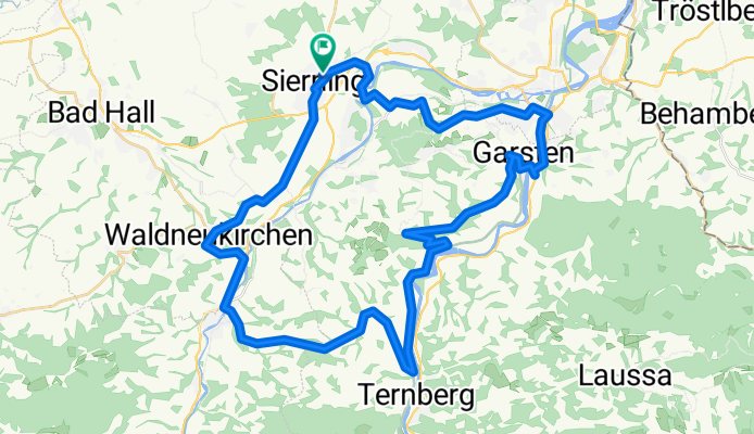
A cycling route starting in Sierning, Upper Austria, Austria.
Overview
About this route
Von Sierining über Waldneukirchen nach Grünburg und über die Sandner Linde nach Ternberg. Weiter über Dürnach bis vor Lahrndorf. Über Rieglwirt in die Hölle, weiter Garsten-Steyr-Pergern-Schwamming-Sierninghofen-Sierning
- -:--
- Duration
- 50 km
- Distance
- 522 m
- Ascent
- 522 m
- Descent
- ---
- Avg. speed
- ---
- Max. altitude

Route quality
Waytypes & surfaces along the route
Waytypes
Road
28.5 km
(57 %)
Quiet road
13 km
(26 %)
Surfaces
Paved
29.5 km
(59 %)
Unpaved
1.5 km
(3 %)
Asphalt
29.5 km
(59 %)
Gravel
1.5 km
(3 %)
Undefined
19 km
(38 %)
Continue with Bikemap
Use, edit, or download this cycling route
You would like to ride Steyrtal_Ennstalrunde or customize it for your own trip? Here is what you can do with this Bikemap route:
Free features
- Save this route as favorite or in collections
- Copy & plan your own version of this route
- Sync your route with Garmin or Wahoo
Premium features
Free trial for 3 days, or one-time payment. More about Bikemap Premium.
- Navigate this route on iOS & Android
- Export a GPX / KML file of this route
- Create your custom printout (try it for free)
- Download this route for offline navigation
Discover more Premium features.
Get Bikemap PremiumFrom our community
Other popular routes starting in Sierning
 Sierning - Hohe Dirn
- Distance
- 36.1 km
- Ascent
- 1,303 m
- Descent
- 785 m
- Location
- Sierning, Upper Austria, Austria
 Café Rafaela steinbach
- Distance
- 11.4 km
- Ascent
- 109 m
- Descent
- 95 m
- Location
- Sierning, Upper Austria, Austria
 Steyr
Steyr- Distance
- 16.1 km
- Ascent
- 155 m
- Descent
- 138 m
- Location
- Sierning, Upper Austria, Austria
 Grünburgerhütte_Hohe Linde
- Distance
- 54.8 km
- Ascent
- 1,015 m
- Descent
- 1,031 m
- Location
- Sierning, Upper Austria, Austria
 #Dambergwarte mW1
- Distance
- 40.8 km
- Ascent
- 942 m
- Descent
- 944 m
- Location
- Sierning, Upper Austria, Austria
 2_Runden
- Distance
- 71.3 km
- Ascent
- 586 m
- Descent
- 588 m
- Location
- Sierning, Upper Austria, Austria
 Hohe Linde-Rundfahrt
- Distance
- 20 km
- Ascent
- 296 m
- Descent
- 318 m
- Location
- Sierning, Upper Austria, Austria
 Laussarunde über Oberdambach
- Distance
- 66.8 km
- Ascent
- 1,651 m
- Descent
- 1,645 m
- Location
- Sierning, Upper Austria, Austria
Open it in the app