

Sípark-Szalajkaház (Mátrai Erdei kerékpárutak: ZÖLD)
A cycling route starting in Bátonyterenye, Nógrád megye, Hungary.
Overview
About this route
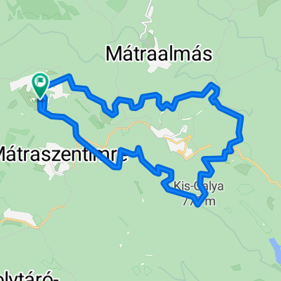
Haladjunk a Síparkból az autóúton a Bőgős-rét felé, majd az autóutat keresztezve guruljunk lefelé a forgalomtól elzárt Görgői úton. (Ha a sorompó le van zárva, kerüld ki.) Pár kilométer után jobbra térjünk le a zöld jelzést követve, innetől köves, dózerúton gurulunk tovább. Több kanyart követően érünk a Cseternás-patakhoz, a patakkal párhuzamosan haldjunk tovább, most már lankásabb úton. Megérkezünk a Szalajkaházhoz egy nagyívű jobbos kanyarral, lejebb található a Erdei Kisvasút Állomás és több pihenő.
- -:--
- Duration
- 7.3 km
- Distance
- 11 m
- Ascent
- 326 m
- Descent
- ---
- Avg. speed
- ---
- Max. altitude

Route photos
\"")
\"")
\"")
\"")
\"")
\"")
Route quality
Waytypes & surfaces along the route
Waytypes
Track
4.4 km
(61 %)
Quiet road
1.5 km
(21 %)
Road
1.3 km
(18 %)
Surfaces
Paved
2.8 km
(39 %)
Unpaved
4.4 km
(61 %)
Gravel
4.4 km
(61 %)
Asphalt
2.8 km
(39 %)
Continue with Bikemap
Use, edit, or download this cycling route
You would like to ride Sípark-Szalajkaház (Mátrai Erdei kerékpárutak: ZÖLD) or customize it for your own trip? Here is what you can do with this Bikemap route:
Free features
- Save this route as favorite or in collections
- Copy & plan your own version of this route
- Sync your route with Garmin or Wahoo
Premium features
Free trial for 3 days, or one-time payment. More about Bikemap Premium.
- Navigate this route on iOS & Android
- Export a GPX / KML file of this route
- Create your custom printout (try it for free)
- Download this route for offline navigation
Discover more Premium features.
Get Bikemap PremiumFrom our community
Other popular routes starting in Bátonyterenye
 Panoráma Körút a Felső Mátrában
- Distance
- 19.4 km
- Ascent
- 308 m
- Descent
- 306 m
- Location
- Bátonyterenye, Nógrád megye, Hungary
 Mátraszentistván/ Sípark- Fekete tó (ZÖLD)
- Distance
- 8.1 km
- Ascent
- 146 m
- Descent
- 221 m
- Location
- Bátonyterenye, Nógrád megye, Hungary
 Kellemes 20 km
- Distance
- 20.2 km
- Ascent
- 310 m
- Descent
- 310 m
- Location
- Bátonyterenye, Nógrád megye, Hungary
 Kazár-Riolittufa
- Distance
- 22.2 km
- Ascent
- 194 m
- Descent
- 194 m
- Location
- Bátonyterenye, Nógrád megye, Hungary
 Mátra Második nap
- Distance
- 19 km
- Ascent
- 365 m
- Descent
- 362 m
- Location
- Bátonyterenye, Nógrád megye, Hungary
 Kis edzés a Mátra északi lábánál I.
- Distance
- 54 km
- Ascent
- 532 m
- Descent
- 532 m
- Location
- Bátonyterenye, Nógrád megye, Hungary
 Sámsonháza
- Distance
- 37.9 km
- Ascent
- 207 m
- Descent
- 207 m
- Location
- Bátonyterenye, Nógrád megye, Hungary
 Karancs
- Distance
- 52.4 km
- Ascent
- 413 m
- Descent
- 417 m
- Location
- Bátonyterenye, Nógrád megye, Hungary
Open it in the app