

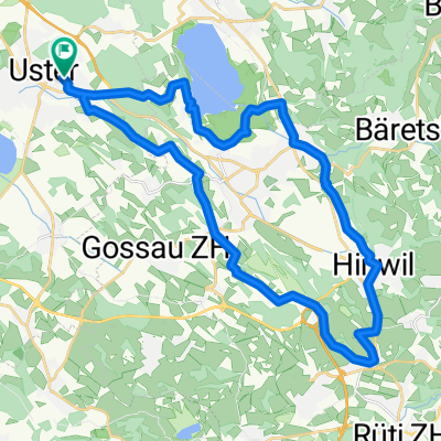
Gschnäu i Coop
A cycling route starting in Uster, Canton of Zurich, Switzerland.
Overview
About this route
×
- -:--
- Duration
- 16.7 km
- Distance
- 110 m
- Ascent
- 113 m
- Descent
- ---
- Avg. speed
- ---
- Max. altitude
Route quality
Waytypes & surfaces along the route
Waytypes
Quiet road
4.8 km
(29 %)
Path
4.5 km
(27 %)
Surfaces
Paved
15 km
(90 %)
Unpaved
1.7 km
(10 %)
Asphalt
14.2 km
(85 %)
Gravel
1.7 km
(10 %)
Paved (undefined)
0.8 km
(5 %)
Continue with Bikemap
Use, edit, or download this cycling route
You would like to ride Gschnäu i Coop or customize it for your own trip? Here is what you can do with this Bikemap route:
Free features
- Save this route as favorite or in collections
- Copy & plan your own version of this route
- Sync your route with Garmin or Wahoo
Premium features
Free trial for 3 days, or one-time payment. More about Bikemap Premium.
- Navigate this route on iOS & Android
- Export a GPX / KML file of this route
- Create your custom printout (try it for free)
- Download this route for offline navigation
Discover more Premium features.
Get Bikemap PremiumFrom our community
Other popular routes starting in Uster
 Uster - Grüningen - Uster Runde
- Distance
- 35.3 km
- Ascent
- 424 m
- Descent
- 423 m
- Location
- Uster, Canton of Zurich, Switzerland
 Hittnau - Agasul - Runde
- Distance
- 39.9 km
- Ascent
- 558 m
- Descent
- 544 m
- Location
- Uster, Canton of Zurich, Switzerland
 Uster - Dürnten - Pfäffikersee - Uster
- Distance
- 33.4 km
- Ascent
- 338 m
- Descent
- 337 m
- Location
- Uster, Canton of Zurich, Switzerland
 Uster - Rapperswil - Uster flach
- Distance
- 55.6 km
- Ascent
- 551 m
- Descent
- 561 m
- Location
- Uster, Canton of Zurich, Switzerland
 Industriestrasse 35, Uster nach Industriestrasse 31, Uster
- Distance
- 23.4 km
- Ascent
- 239 m
- Descent
- 236 m
- Location
- Uster, Canton of Zurich, Switzerland
 Uster - Grüningen - Uster kurz
- Distance
- 29.4 km
- Ascent
- 272 m
- Descent
- 271 m
- Location
- Uster, Canton of Zurich, Switzerland
 Uster - Wangen - Uster - Runde
- Distance
- 24.1 km
- Ascent
- 232 m
- Descent
- 236 m
- Location
- Uster, Canton of Zurich, Switzerland
 ¿ˇ´Ò? nach ¿ˇ´Ò?
- Distance
- 24 km
- Ascent
- 330 m
- Descent
- 330 m
- Location
- Uster, Canton of Zurich, Switzerland
Open it in the app