Leicht hügelige Trainingsroute
- 38 km
- 401 m
- 404 m
- Hessigheim, Baden-Wurttemberg, Germany
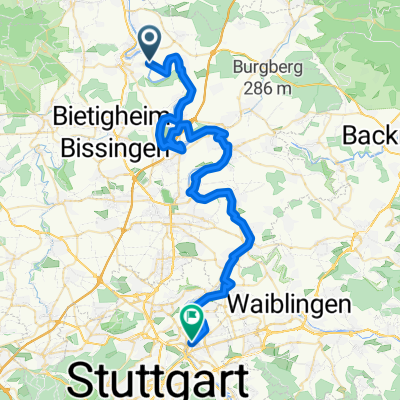
A cycling route starting in Hessigheim, Baden-Wurttemberg, Germany.
Overview
As always, the route starts at the lock in Hessigheim. You follow the bike path along the Neckar towards Mundelsheim. In Mundelsheim, instead of taking the new bike path towards Pleidelsheim, you take the small climb at the edge of town towards Hart. On the plateau, you are directly above the quarry with a great view inside and down to the Neckar.
The route continues alongside the quarry, crossing over the highway on a small descent into Höpfigheim. In Höpfigheim, you ride along the main street towards Steinheim and turn slightly left at the town's edge onto the old connecting road towards Großbottwar.
Arriving in Großbottwar, you cross the main road and continue on the Bottwartal bike path towards Oberstenfeld. At Sauserhof, turn right and you can see ahead the Lichtenfels Castle and the steep climb up (the challenging part of the route). Once at the top, turn left onto the main road back towards Oberstenfeld and take the fast descent through the forest. Here, be careful: before you see the first houses, the climb turns left again into the vineyards, as you want to tackle the climb once more. So back up to the castle (this time only about two-thirds of the climb)... At the top, as usual, turn left through the forest back and you can decide if you want to do the climb again. On nice days, I do it up to six times as it’s great training.
The return is the same as the outward route via Sauserhof, Großbottwar, Höpfigheim (possibly up to the quarry again), Mundelsheim and Hessigheim. In Mundelsheim, you can also easily combine this route with my other daily training route... Have fun!
created this 15 years ago
Route quality
Track
16.1 km
(47 %)
Quiet road
8.2 km
(24 %)
Paved
28.7 km
(84 %)
Unpaved
2.1 km
(6 %)
Asphalt
27 km
(79 %)
Paved (undefined)
1.7 km
(5 %)
Continue with Bikemap
You would like to ride 2. Trainingsroute etwas anspruchsvoller or customize it for your own trip? Here is what you can do with this Bikemap route:
Free trial for 3 days, or one-time payment. More about Bikemap Premium.
Discover more Premium features.
Get Bikemap PremiumFrom our community
Open it in the app