

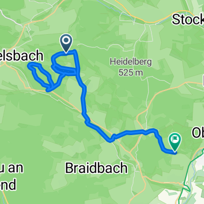
Urspringen-Ellenbogen
A cycling route starting in Sondheim vor der Rhön, Bavaria, Germany.
Overview
About this route
- -:--
- Duration
- 45.6 km
- Distance
- 857 m
- Ascent
- 841 m
- Descent
- ---
- Avg. speed
- ---
- Max. altitude
Route photos


Route quality
Waytypes & surfaces along the route
Waytypes
Track
20.8 km
(46 %)
Quiet road
8.7 km
(19 %)
Surfaces
Paved
27 km
(59 %)
Unpaved
15.5 km
(34 %)
Asphalt
24.2 km
(53 %)
Gravel
6.1 km
(13 %)
Continue with Bikemap
Use, edit, or download this cycling route
You would like to ride Urspringen-Ellenbogen or customize it for your own trip? Here is what you can do with this Bikemap route:
Free features
- Save this route as favorite or in collections
- Copy & plan your own version of this route
- Sync your route with Garmin or Wahoo
Premium features
Free trial for 3 days, or one-time payment. More about Bikemap Premium.
- Navigate this route on iOS & Android
- Export a GPX / KML file of this route
- Create your custom printout (try it for free)
- Download this route for offline navigation
Discover more Premium features.
Get Bikemap PremiumFrom our community
Other popular routes starting in Sondheim vor der Rhön
 Urspringen- Gukaisee
- Distance
- 50.8 km
- Ascent
- 4,011 m
- Descent
- 4,011 m
- Location
- Sondheim vor der Rhön, Bavaria, Germany
 Schnelle Tour in Mellrichstadt
- Distance
- 12.9 km
- Ascent
- 59 m
- Descent
- 142 m
- Location
- Sondheim vor der Rhön, Bavaria, Germany
 Rhön 2016 Runde 1
- Distance
- 48.8 km
- Ascent
- 683 m
- Descent
- 683 m
- Location
- Sondheim vor der Rhön, Bavaria, Germany
 Urspringen-Ellenbogen
- Distance
- 45.6 km
- Ascent
- 857 m
- Descent
- 841 m
- Location
- Sondheim vor der Rhön, Bavaria, Germany
 Geocache Oberwaldberungen
- Distance
- 22.8 km
- Ascent
- 278 m
- Descent
- 411 m
- Location
- Sondheim vor der Rhön, Bavaria, Germany
 Sondheim v.d.R.-Meiningen
- Distance
- 28.7 km
- Ascent
- 197 m
- Descent
- 302 m
- Location
- Sondheim vor der Rhön, Bavaria, Germany
 9k berg
- Distance
- 8.6 km
- Ascent
- 396 m
- Descent
- 8 m
- Location
- Sondheim vor der Rhön, Bavaria, Germany
 Im Naturpark Bayerische Rhön
- Distance
- 49.7 km
- Ascent
- 648 m
- Descent
- 648 m
- Location
- Sondheim vor der Rhön, Bavaria, Germany
Open it in the app