Bike and Hike auf den Largoz
A cycling route starting in Tulfes, Tyrol, Austria.
Overview
About this route
Beautiful tour with three easy peaks
From the Volderwildbad parking lot, first 800 vertical meters towards Largozalm. From there, continue with two more hairpin bends on the Fortsweg path. At the marker on the map, park the bike and take a barely noticeable path to the main trail leading to Largoz, about 250 vertical meters.
The tour can also be undertaken as a circular route. From the summit of Largoz, continue along a very easy ridge to Wattener Spitze and from there further to Rosskopf. From here, descend towards Haneburger and take the right turn back to Largozalm.
- -:--
- Duration
- 12.8 km
- Distance
- 1,280 m
- Ascent
- 371 m
- Descent
- ---
- Avg. speed
- ---
- Max. altitude
Route highlights
Points of interest along the route
Point of interest after 7.7 km
Hier das Rad stehen lassen
Continue with Bikemap
Use, edit, or download this cycling route
You would like to ride Bike and Hike auf den Largoz or customize it for your own trip? Here is what you can do with this Bikemap route:
Free features
- Save this route as favorite or in collections
- Copy & plan your own version of this route
- Sync your route with Garmin or Wahoo
Premium features
Free trial for 3 days, or one-time payment. More about Bikemap Premium.
- Navigate this route on iOS & Android
- Export a GPX / KML file of this route
- Create your custom printout (try it for free)
- Download this route for offline navigation
Discover more Premium features.
Get Bikemap PremiumFrom our community
Other popular routes starting in Tulfes
- Voldertal 25–26, Tulfes nach Voldertal 25, Tulfes
- Distance
- 1.5 km
- Ascent
- 156 m
- Descent
- 0 m
- Location
- Tulfes, Tyrol, Austria
- Majówka - Narciarsko, Rowerowo Tyrol Austria
- Distance
- 332.3 km
- Ascent
- 2,559 m
- Descent
- 2,559 m
- Location
- Tulfes, Tyrol, Austria
- Majówka rowerowo, Narciarsko Tyrol Austria,Kaprun.
- Distance
- 332.1 km
- Ascent
- 2,491 m
- Descent
- 2,491 m
- Location
- Tulfes, Tyrol, Austria
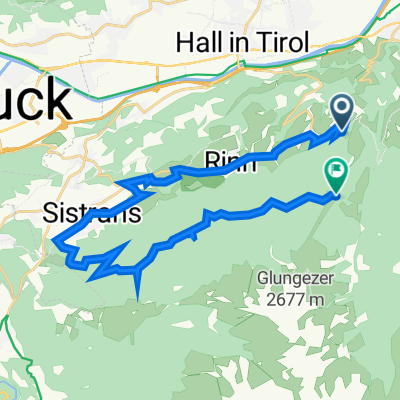
- Voldertalhütte - Tulfein
- Distance
- 24.7 km
- Ascent
- 1,304 m
- Descent
- 1,302 m
- Location
- Tulfes, Tyrol, Austria
- Tour Tulfeinalm
- Distance
- 9.7 km
- Ascent
- 1,229 m
- Descent
- 120 m
- Location
- Tulfes, Tyrol, Austria
- 08: Tulfes – Mayrhofen
- Distance
- 53.4 km
- Ascent
- 1,868 m
- Descent
- 2,132 m
- Location
- Tulfes, Tyrol, Austria
- Mittelgebirge Innsbruck - Pisa über Florenz [Konzept] v2
- Distance
- 661.3 km
- Ascent
- 1,398 m
- Descent
- 2,305 m
- Location
- Tulfes, Tyrol, Austria
- Route nach Wattenberg 3C, Keilfeld
- Distance
- 4,248.1 km
- Ascent
- 928 m
- Descent
- 1,907 m
- Location
- Tulfes, Tyrol, Austria
Open it in the app