

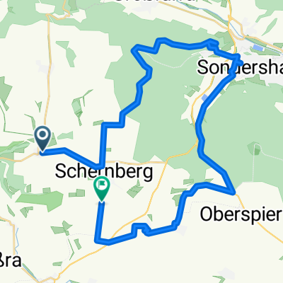
2019 Thüringen Helbe Tal
A cycling route starting in Schernberg, Thuringia, Germany.
Overview
About this route
the helbe unfortunately completely dry
incredible
extreme dryness
beautiful valley
partially dirt road through meadow
- -:--
- Duration
- 15.3 km
- Distance
- 194 m
- Ascent
- 194 m
- Descent
- ---
- Avg. speed
- ---
- Max. altitude
Route quality
Waytypes & surfaces along the route
Waytypes
Track
11 km
(72 %)
Quiet road
0.5 km
(3 %)
Undefined
3.8 km
(25 %)
Surfaces
Paved
2.8 km
(18 %)
Unpaved
11.2 km
(73 %)
Gravel
8.3 km
(54 %)
Ground
2.9 km
(19 %)
Route highlights
Points of interest along the route
Point of interest after 9.4 km
pausenplatz
Continue with Bikemap
Use, edit, or download this cycling route
You would like to ride 2019 Thüringen Helbe Tal or customize it for your own trip? Here is what you can do with this Bikemap route:
Free features
- Save this route as favorite or in collections
- Copy & plan your own version of this route
- Sync your route with Garmin or Wahoo
Premium features
Free trial for 3 days, or one-time payment. More about Bikemap Premium.
- Navigate this route on iOS & Android
- Export a GPX / KML file of this route
- Create your custom printout (try it for free)
- Download this route for offline navigation
Discover more Premium features.
Get Bikemap PremiumFrom our community
Other popular routes starting in Schernberg
 2019 Thüringen Helbe Tal
- Distance
- 15.3 km
- Ascent
- 194 m
- Descent
- 194 m
- Location
- Schernberg, Thuringia, Germany
 Am Bahnhofsberg 3, Sondershausen nach Zum Park 12, Sondershausen
- Distance
- 5.4 km
- Ascent
- 15 m
- Descent
- 86 m
- Location
- Schernberg, Thuringia, Germany
 Sondershäuser Straße, Sondershausen nach L2085, Sondershausen
- Distance
- 2.5 km
- Ascent
- 63 m
- Descent
- 46 m
- Location
- Schernberg, Thuringia, Germany
 Schernberg - Braunlage
- Distance
- 62.6 km
- Ascent
- 507 m
- Descent
- 242 m
- Location
- Schernberg, Thuringia, Germany
 Straße ohne Straßennamen, Sondershausen nach Oberer Hasselweg 1, Sondershausen
- Distance
- 9 km
- Ascent
- 130 m
- Descent
- 337 m
- Location
- Schernberg, Thuringia, Germany
 Windmühlenweg 5, Sondershausen nach Steinstraße 1, Ebeleben
- Distance
- 12.3 km
- Ascent
- 107 m
- Descent
- 148 m
- Location
- Schernberg, Thuringia, Germany
 Siedlerweg, Sondershausen nach Bahnhofstraße, Bad Langensalza
- Distance
- 49.1 km
- Ascent
- 117 m
- Descent
- 240 m
- Location
- Schernberg, Thuringia, Germany
 Tobaer Straße, Sondershausen nach Gunderslebener Straße, Sondershausen
- Distance
- 33 km
- Ascent
- 426 m
- Descent
- 464 m
- Location
- Schernberg, Thuringia, Germany
Open it in the app