

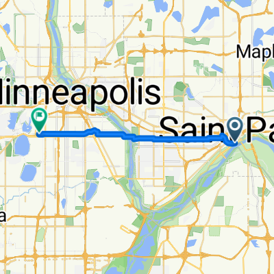
B2B00629 55102 < 55402 via Summit, River Road, West bank, Downtown
A cycling route starting in Saint Paul, Minnesota, United States.
Overview
About this route
- -:--
- Duration
- 15.5 km
- Distance
- 82 m
- Ascent
- 94 m
- Descent
- ---
- Avg. speed
- 291 m
- Max. altitude
Route quality
Waytypes & surfaces along the route
Waytypes
Road
9 km
(58 %)
Quiet road
3.5 km
(23 %)
Surfaces
Paved
11 km
(71 %)
Asphalt
8.2 km
(53 %)
Paved (undefined)
2.4 km
(15 %)
Continue with Bikemap
Use, edit, or download this cycling route
You would like to ride B2B00629 55102 < 55402 via Summit, River Road, West bank, Downtown or customize it for your own trip? Here is what you can do with this Bikemap route:
Free features
- Save this route as favorite or in collections
- Copy & plan your own version of this route
- Sync your route with Garmin or Wahoo
Premium features
Free trial for 3 days, or one-time payment. More about Bikemap Premium.
- Navigate this route on iOS & Android
- Export a GPX / KML file of this route
- Create your custom printout (try it for free)
- Download this route for offline navigation
Discover more Premium features.
Get Bikemap PremiumFrom our community
Other popular routes starting in Saint Paul
 Como & Phalen Bike Way
- Distance
- 29 km
- Ascent
- 191 m
- Descent
- 191 m
- Location
- Saint Paul, Minnesota, United States
 B2B00062 55106 - 55075 via Concord, NURT
- Distance
- 9.5 km
- Ascent
- 80 m
- Descent
- 110 m
- Location
- Saint Paul, Minnesota, United States
 River Ramble 20
- Distance
- 29.6 km
- Ascent
- 196 m
- Descent
- 197 m
- Location
- Saint Paul, Minnesota, United States
 B2B00024 55104 > 55121 via Big Rivers Trail
- Distance
- 16.8 km
- Ascent
- 174 m
- Descent
- 174 m
- Location
- Saint Paul, Minnesota, United States
 Way to Church
- Distance
- 13.2 km
- Ascent
- 54 m
- Descent
- 37 m
- Location
- Saint Paul, Minnesota, United States
 To the River Center
- Distance
- 17.1 km
- Ascent
- 117 m
- Descent
- 90 m
- Location
- Saint Paul, Minnesota, United States
 B2B00368 55102 > 55417 via Shepard Rd, Godfrey, Minnehaha, River Pkwy
- Distance
- 17.8 km
- Ascent
- 96 m
- Descent
- 119 m
- Location
- Saint Paul, Minnesota, United States
 B2B00192 55102>55404viaShepherdRd/MissBlvd/WRiverPkwy/MidtwnGrnway
- Distance
- 21.8 km
- Ascent
- 131 m
- Descent
- 86 m
- Location
- Saint Paul, Minnesota, United States
Open it in the app