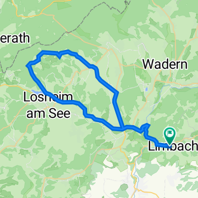
Mövenmarathon 2008 - RTF des RV Möve Schmelz e.V. - 202 km Strecke
A cycling route starting in Schmelz, Saarland, Germany.
Overview
About this route
here is my tour with club mates Hein and Helmut from 18.05.2008 with lightning, hail, and freezing rain
- -:--
- Duration
- 200.1 km
- Distance
- 1,450 m
- Ascent
- 1,450 m
- Descent
- ---
- Avg. speed
- ---
- Max. altitude
Route quality
Waytypes & surfaces along the route
Waytypes
Road
36 km
(18 %)
Quiet road
32 km
(16 %)
Surfaces
Paved
150.1 km
(75 %)
Unpaved
16 km
(8 %)
Asphalt
140.1 km
(70 %)
Gravel
12 km
(6 %)
Route highlights
Points of interest along the route
Point of interest after 21.4 km
Kontrolle 1 Beckingen
Point of interest after 50.7 km
Kontrolle 2 Waldhölzbach
Point of interest after 81.4 km
Kontrolle 3 Ollmuth
Point of interest after 107.4 km
Kontrolle 4 Wadrill
Point of interest after 141.4 km
Kontrolle 5 Börfink
Point of interest after 172.4 km
Kontrolle 6 Kastel
Continue with Bikemap
Use, edit, or download this cycling route
You would like to ride Mövenmarathon 2008 - RTF des RV Möve Schmelz e.V. - 202 km Strecke or customize it for your own trip? Here is what you can do with this Bikemap route:
Free features
- Save this route as favorite or in collections
- Copy & plan your own version of this route
- Split it into stages to create a multi-day tour
- Sync your route with Garmin or Wahoo
Premium features
Free trial for 3 days, or one-time payment. More about Bikemap Premium.
- Navigate this route on iOS & Android
- Export a GPX / KML file of this route
- Create your custom printout (try it for free)
- Download this route for offline navigation
Discover more Premium features.
Get Bikemap PremiumFrom our community
Other popular routes starting in Schmelz
Hochwaldtrail- Distance
- 71.4 km
- Ascent
- 1,047 m
- Descent
- 1,050 m
- Location
- Schmelz, Saarland, Germany
Wendelinus-Fahrt 2013 - RTF des RSC Haustadter Tal Reimsbach e.V. - 80 km Strecke- Distance
- 72.4 km
- Ascent
- 459 m
- Descent
- 459 m
- Location
- Schmelz, Saarland, Germany
Saar Permanente 2013 - 75 km Perm. des RSC Haustadter Tal Reimsbach e.V.- Distance
- 68.7 km
- Ascent
- 718 m
- Descent
- 747 m
- Location
- Schmelz, Saarland, Germany
Limbach Hoxfels- Distance
- 11.7 km
- Ascent
- 282 m
- Descent
- 281 m
- Location
- Schmelz, Saarland, Germany
Mühlenbach und Schluchtenweg in Saarwelingen/Endsdorf- Distance
- 38.8 km
- Ascent
- 288 m
- Descent
- 289 m
- Location
- Schmelz, Saarland, Germany
Limbach - Höchsten- Distance
- 10.7 km
- Ascent
- 269 m
- Descent
- 268 m
- Location
- Schmelz, Saarland, Germany
Limbach zu Burg Dagstuhl- Distance
- 21.2 km
- Ascent
- 266 m
- Descent
- 266 m
- Location
- Schmelz, Saarland, Germany
Wendelinus-Fahrt 2013 - RTF des RSC Haustadter Tal Reimsbach e.V. - 51 km Strecke- Distance
- 48.1 km
- Ascent
- 413 m
- Descent
- 361 m
- Location
- Schmelz, Saarland, Germany
Open it in the app


