

Hochalpintour um Gressoney St.Jean
A cycling route starting in Gressoney-Saint-Jean, Aosta Valley, Italy.
Overview
About this route
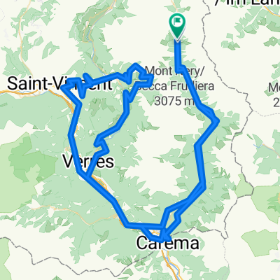
Steimatto - Weissmatten Sessellift Weissmatten Weissmatten - Col Ranzola Col Ranzola - Brusson Brusson - Salamon Salamon - Extrepieraz Extrepieraz - Champoluc Sessellift Champoluc - Ostafa Ostafa - Col Sarezza Col Sarezza - Col Bettaforca Col Bettaforca - Staffal Staffal - Steimatto
- -:--
- Duration
- 53.6 km
- Distance
- 2,843 m
- Ascent
- 2,837 m
- Descent
- ---
- Avg. speed
- ---
- Max. altitude
Continue with Bikemap
Use, edit, or download this cycling route
You would like to ride Hochalpintour um Gressoney St.Jean or customize it for your own trip? Here is what you can do with this Bikemap route:
Free features
- Save this route as favorite or in collections
- Copy & plan your own version of this route
- Sync your route with Garmin or Wahoo
Premium features
Free trial for 3 days, or one-time payment. More about Bikemap Premium.
- Navigate this route on iOS & Android
- Export a GPX / KML file of this route
- Create your custom printout (try it for free)
- Download this route for offline navigation
Discover more Premium features.
Get Bikemap PremiumFrom our community
Other popular routes starting in Gressoney-Saint-Jean
 Gressoney-Saint-Jean Cycling
- Distance
- 27.4 km
- Ascent
- 726 m
- Descent
- 603 m
- Location
- Gressoney-Saint-Jean, Aosta Valley, Italy
 Gressoney-Saint-Jean Cycling
- Distance
- 9.4 km
- Ascent
- 494 m
- Descent
- 470 m
- Location
- Gressoney-Saint-Jean, Aosta Valley, Italy
 Gressoney-Saint-Jean Cycling
- Distance
- 110.5 km
- Ascent
- 302 m
- Descent
- 1,416 m
- Location
- Gressoney-Saint-Jean, Aosta Valley, Italy
 Da Località Laubono a Località Laubono
- Distance
- 171.4 km
- Ascent
- 7,006 m
- Descent
- 7,006 m
- Location
- Gressoney-Saint-Jean, Aosta Valley, Italy
 Hochalpintour um Gressoney St.Jean
- Distance
- 53.6 km
- Ascent
- 2,843 m
- Descent
- 2,837 m
- Location
- Gressoney-Saint-Jean, Aosta Valley, Italy
 Gressoney-Saint-Jean Cycling
- Distance
- 41.8 km
- Ascent
- 1,040 m
- Descent
- 1,040 m
- Location
- Gressoney-Saint-Jean, Aosta Valley, Italy
 Gressoney-Saint-Jean Cycling
- Distance
- 35.3 km
- Ascent
- 966 m
- Descent
- 973 m
- Location
- Gressoney-Saint-Jean, Aosta Valley, Italy
 Col Ranzola
- Distance
- 11.8 km
- Ascent
- 864 m
- Descent
- 410 m
- Location
- Gressoney-Saint-Jean, Aosta Valley, Italy
Open it in the app