

Verbindung von Wiesloch nach Heidelberg
A cycling route starting in Wiesloch, Baden-Wurttemberg, Germany.
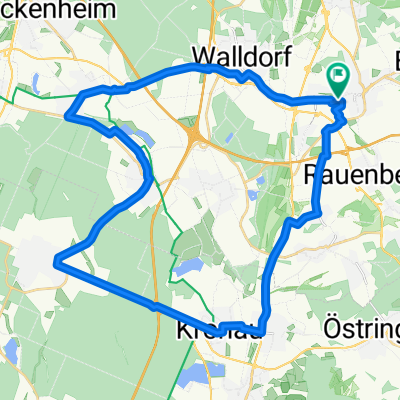
Overview
About this route
This is the most direct route from Wiesloch to Heidelberg via Nußloch and Leimen, across the plain, largely avoiding busy roads.
- -:--
- Duration
- 14.8 km
- Distance
- 76 m
- Ascent
- 92 m
- Descent
- ---
- Avg. speed
- ---
- Max. altitude
Route quality
Waytypes & surfaces along the route
Waytypes
Quiet road
9 km
(61 %)
Track
3 km
(20 %)
Surfaces
Paved
13.1 km
(89 %)
Asphalt
12.9 km
(87 %)
Paved (undefined)
0.1 km
(1 %)
Continue with Bikemap
Use, edit, or download this cycling route
You would like to ride Verbindung von Wiesloch nach Heidelberg or customize it for your own trip? Here is what you can do with this Bikemap route:
Free features
- Save this route as favorite or in collections
- Copy & plan your own version of this route
- Sync your route with Garmin or Wahoo
Premium features
Free trial for 3 days, or one-time payment. More about Bikemap Premium.
- Navigate this route on iOS & Android
- Export a GPX / KML file of this route
- Create your custom printout (try it for free)
- Download this route for offline navigation
Discover more Premium features.
Get Bikemap PremiumFrom our community
Other popular routes starting in Wiesloch
 Wiesloch - Königstuhl
- Distance
- 15.6 km
- Ascent
- 519 m
- Descent
- 85 m
- Location
- Wiesloch, Baden-Wurttemberg, Germany
 Reilingen - Kirrlach -Bad Schönborn
- Distance
- 37.7 km
- Ascent
- 76 m
- Descent
- 70 m
- Location
- Wiesloch, Baden-Wurttemberg, Germany
 Weinbergrundtour Wiesloch
- Distance
- 8.3 km
- Ascent
- 104 m
- Descent
- 100 m
- Location
- Wiesloch, Baden-Wurttemberg, Germany
 move-Tour 03.1 Zum St. Leoner See
- Distance
- 23.3 km
- Ascent
- 40 m
- Descent
- 56 m
- Location
- Wiesloch, Baden-Wurttemberg, Germany
 Schoppingtour rund um Wiesloch
- Distance
- 46.4 km
- Ascent
- 129 m
- Descent
- 131 m
- Location
- Wiesloch, Baden-Wurttemberg, Germany
 move-Tour 1: Zum Golfplatz St. Leon-Rot
- Distance
- 21.1 km
- Ascent
- 47 m
- Descent
- 60 m
- Location
- Wiesloch, Baden-Wurttemberg, Germany
 Wiesloch-Hoffenheim-Eschelbach
- Distance
- 31.8 km
- Ascent
- 363 m
- Descent
- 356 m
- Location
- Wiesloch, Baden-Wurttemberg, Germany
 Drei Zinnen
- Distance
- 83.6 km
- Ascent
- 1,673 m
- Descent
- 1,658 m
- Location
- Wiesloch, Baden-Wurttemberg, Germany
Open it in the app