

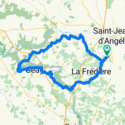
Saint Jean d'Angély Pons 66 Km
A cycling route starting in Saint-Jean-d'Angély, Nouvelle-Aquitaine, France.
Overview
About this route
- -:--
- Duration
- 55.7 km
- Distance
- 272 m
- Ascent
- 289 m
- Descent
- ---
- Avg. speed
- ---
- Max. altitude
Route quality
Waytypes & surfaces along the route
Waytypes
Road
27.8 km
(50 %)
Quiet road
22.8 km
(41 %)
Surfaces
Paved
18.9 km
(34 %)
Unpaved
0.6 km
(1 %)
Asphalt
18.4 km
(33 %)
Paved (undefined)
0.6 km
(1 %)
Continue with Bikemap
Use, edit, or download this cycling route
You would like to ride Saint Jean d'Angély Pons 66 Km or customize it for your own trip? Here is what you can do with this Bikemap route:
Free features
- Save this route as favorite or in collections
- Copy & plan your own version of this route
- Sync your route with Garmin or Wahoo
Premium features
Free trial for 3 days, or one-time payment. More about Bikemap Premium.
- Navigate this route on iOS & Android
- Export a GPX / KML file of this route
- Create your custom printout (try it for free)
- Download this route for offline navigation
Discover more Premium features.
Get Bikemap PremiumFrom our community
Other popular routes starting in Saint-Jean-d'Angély
 Facile à conduire Loulay
- Distance
- 15.5 km
- Ascent
- 86 m
- Descent
- 85 m
- Location
- Saint-Jean-d'Angély, Nouvelle-Aquitaine, France
 2016-07-20 Saint-Jean-dAngély - LeVerdon-sur-Mer Tag 10
- Distance
- 97.9 km
- Ascent
- ---
- Descent
- ---
- Location
- Saint-Jean-d'Angély, Nouvelle-Aquitaine, France
 étape ride #6 Taillebourg maya châteaux
- Distance
- 70.3 km
- Ascent
- 394 m
- Descent
- 390 m
- Location
- Saint-Jean-d'Angély, Nouvelle-Aquitaine, France
 De Quai de Bernouet 26, Saint-Jean-d'Angély à Rue de Ganochaud 67, Ternant
- Distance
- 3.3 km
- Ascent
- 61 m
- Descent
- 6 m
- Location
- Saint-Jean-d'Angély, Nouvelle-Aquitaine, France
 Voie comme un escargot dans Loulay
- Distance
- 11.7 km
- Ascent
- 56 m
- Descent
- 58 m
- Location
- Saint-Jean-d'Angély, Nouvelle-Aquitaine, France
 les Granges
- Distance
- 15.9 km
- Ascent
- 88 m
- Descent
- 96 m
- Location
- Saint-Jean-d'Angély, Nouvelle-Aquitaine, France
 Day 19 - Lucca to London - Saint Jean d'Angely to Fontenay le Comte
- Distance
- 80.2 km
- Ascent
- 283 m
- Descent
- 237 m
- Location
- Saint-Jean-d'Angély, Nouvelle-Aquitaine, France
 De Route de Taillebourg 2, Mazeray à Rue Thomas Edison 6, Dolus-d'Oléron
- Distance
- 71.9 km
- Ascent
- 149 m
- Descent
- 217 m
- Location
- Saint-Jean-d'Angély, Nouvelle-Aquitaine, France
Open it in the app