

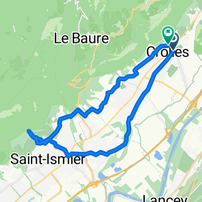
1/ Crolles - Culoz
A cycling route starting in Crolles, Auvergne-Rhône-Alpes, France.
Overview
About this route
- -:--
- Duration
- 89 km
- Distance
- 315 m
- Ascent
- 323 m
- Descent
- ---
- Avg. speed
- ---
- Max. altitude

Route quality
Waytypes & surfaces along the route
Waytypes
Quiet road
32 km
(36 %)
Cycleway
19.6 km
(22 %)
Surfaces
Paved
44.5 km
(50 %)
Unpaved
1.8 km
(2 %)
Asphalt
44.5 km
(50 %)
Gravel
0.9 km
(1 %)
Route highlights
Points of interest along the route
Point of interest after 26 km
Continue with Bikemap
Use, edit, or download this cycling route
You would like to ride 1/ Crolles - Culoz or customize it for your own trip? Here is what you can do with this Bikemap route:
Free features
- Save this route as favorite or in collections
- Copy & plan your own version of this route
- Split it into stages to create a multi-day tour
- Sync your route with Garmin or Wahoo
Premium features
Free trial for 3 days, or one-time payment. More about Bikemap Premium.
- Navigate this route on iOS & Android
- Export a GPX / KML file of this route
- Create your custom printout (try it for free)
- Download this route for offline navigation
Discover more Premium features.
Get Bikemap PremiumFrom our community
Other popular routes starting in Crolles
 tour 17
- Distance
- 231.2 km
- Ascent
- 5,089 m
- Descent
- 3,530 m
- Location
- Crolles, Auvergne-Rhône-Alpes, France
 Avenue de la Résistance, Crolles à Avenue de la Résistance, Crolles
- Distance
- 17.3 km
- Ascent
- 401 m
- Descent
- 401 m
- Location
- Crolles, Auvergne-Rhône-Alpes, France
 De Place de l'Emendra à Place de l'Emendra
- Distance
- 11.5 km
- Ascent
- 114 m
- Descent
- 166 m
- Location
- Crolles, Auvergne-Rhône-Alpes, France
 Grenoble-Vizille-Allemond-Vizille
- Distance
- 121.6 km
- Ascent
- 933 m
- Descent
- 904 m
- Location
- Crolles, Auvergne-Rhône-Alpes, France
 Rhone-Alpes: Etappe 5
- Distance
- 80.8 km
- Ascent
- 2,120 m
- Descent
- 2,078 m
- Location
- Crolles, Auvergne-Rhône-Alpes, France
 Essai Trike à Crolles 38
- Distance
- 5.1 km
- Ascent
- 56 m
- Descent
- 56 m
- Location
- Crolles, Auvergne-Rhône-Alpes, France
 De Place de l'Emendra à Place de l'Emendra
- Distance
- 16.3 km
- Ascent
- 134 m
- Descent
- 184 m
- Location
- Crolles, Auvergne-Rhône-Alpes, France
 De Place de l'Emendra à Place de l'Emendra
- Distance
- 16.7 km
- Ascent
- 82 m
- Descent
- 136 m
- Location
- Crolles, Auvergne-Rhône-Alpes, France
Open it in the app