
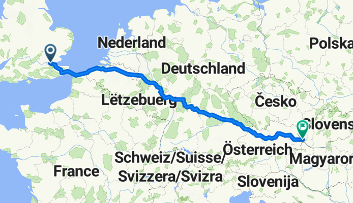
lon - ba
A cycling route starting in Bexleyheath, England, United Kingdom.
Overview
About this route
- -:--
- Duration
- 1,720.1 km
- Distance
- 873 m
- Ascent
- 787 m
- Descent
- ---
- Avg. speed
- ---
- Max. altitude

Route quality
Waytypes & surfaces along the route
Waytypes
Quiet road
453.8 km
(26 %)
Cycleway
324.4 km
(19 %)
Surfaces
Paved
1,326.4 km
(77 %)
Unpaved
75.6 km
(4 %)
Asphalt
1,169.4 km
(68 %)
Paving stones
54.4 km
(3 %)
Continue with Bikemap
Use, edit, or download this cycling route
You would like to ride lon - ba or customize it for your own trip? Here is what you can do with this Bikemap route:
Free features
- Save this route as favorite or in collections
- Copy & plan your own version of this route
- Split it into stages to create a multi-day tour
- Sync your route with Garmin or Wahoo
Premium features
Free trial for 3 days, or one-time payment. More about Bikemap Premium.
- Navigate this route on iOS & Android
- Export a GPX / KML file of this route
- Create your custom printout (try it for free)
- Download this route for offline navigation
Discover more Premium features.
Get Bikemap PremiumFrom our community
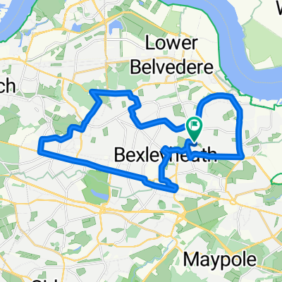
Other popular routes starting in Bexleyheath
 New Bike Ride - Bexleyheath/Sidcup Loop
- Distance
- 18.3 km
- Ascent
- 137 m
- Descent
- 139 m
- Location
- Bexleyheath, England, United Kingdom
 Monday Morning Bike Ride
- Distance
- 21.2 km
- Ascent
- 102 m
- Descent
- 102 m
- Location
- Bexleyheath, England, United Kingdom
 Dallin Road 44A to Sterling Road 22
- Distance
- 13.8 km
- Ascent
- 61 m
- Descent
- 57 m
- Location
- Bexleyheath, England, United Kingdom
 Sterling Road 21 to Sterling Road 21
- Distance
- 27.3 km
- Ascent
- 223 m
- Descent
- 225 m
- Location
- Bexleyheath, England, United Kingdom
 Sterling Road 22 to Sterling Road 22
- Distance
- 20.7 km
- Ascent
- 153 m
- Descent
- 153 m
- Location
- Bexleyheath, England, United Kingdom
 Bexleyheath - Chelsfield - Eynsford
- Distance
- 45.7 km
- Ascent
- 18 m
- Descent
- 0 m
- Location
- Bexleyheath, England, United Kingdom
 Eltham 15KM MB
- Distance
- 15 km
- Ascent
- 84 m
- Descent
- 83 m
- Location
- Bexleyheath, England, United Kingdom
 lon - ba
- Distance
- 1,720.1 km
- Ascent
- 873 m
- Descent
- 787 m
- Location
- Bexleyheath, England, United Kingdom
Open it in the app