

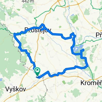
Z Chválkovic do Chválkovic - 95km
A cycling route starting in Ivanovice na Hané, South Moravian, Czechia.
Overview
About this route
A 95 km cycling route for participants of the Chválkovice tourists' event, from Chválkovice to Chválkovice.
Of course, I wouldn't be myself if I didn't get lost at least twice. The detours are marked on the map :D
Shortly before Tovačov, I met a raccoon in the forest. I thought I had a photo with it, but later at home I confirmed that the North American raccoon indeed lives wild here.
The first 70 km is an absolutely, really completely flat plain where you can ride fast. Then comes the climb to Plumlov, and after that the terrain alternates - downhill, uphill, downhill...
According to the cyclocomputer, 103.74 km including detours, so without them it might really be those 95 ;) It's also rideable on a trekking bike, there are few off-road sections.
- -:--
- Duration
- 100.1 km
- Distance
- 278 m
- Ascent
- 278 m
- Descent
- ---
- Avg. speed
- ---
- Max. altitude
Route quality
Waytypes & surfaces along the route
Waytypes
Road
51 km
(51 %)
Track
16 km
(16 %)
Surfaces
Paved
30 km
(30 %)
Unpaved
9 km
(9 %)
Asphalt
26 km
(26 %)
Gravel
6 km
(6 %)
Route highlights
Points of interest along the route
Point of interest after 33.8 km
Tady se má jet doleva. Je to velký rozcestí, dobře značený. Jen někeří se asi zamysleli a jeli rovně :D
Point of interest after 59.6 km
Zde, pro změnu, pokus o přemýšlení nad cestou a špatná volba :D
Continue with Bikemap
Use, edit, or download this cycling route
You would like to ride Z Chválkovic do Chválkovic - 95km or customize it for your own trip? Here is what you can do with this Bikemap route:
Free features
- Save this route as favorite or in collections
- Copy & plan your own version of this route
- Split it into stages to create a multi-day tour
- Sync your route with Garmin or Wahoo
Premium features
Free trial for 3 days, or one-time payment. More about Bikemap Premium.
- Navigate this route on iOS & Android
- Export a GPX / KML file of this route
- Create your custom printout (try it for free)
- Download this route for offline navigation
Discover more Premium features.
Get Bikemap PremiumFrom our community
Other popular routes starting in Ivanovice na Hané
 CYKLO JÍZDA
- Distance
- 96.1 km
- Ascent
- 111 m
- Descent
- 111 m
- Location
- Ivanovice na Hané, South Moravian, Czechia
 Na kole Ivanovickou Bránou 2010 (Trasa B - Lesem)
- Distance
- 29.6 km
- Ascent
- 362 m
- Descent
- 363 m
- Location
- Ivanovice na Hané, South Moravian, Czechia
 Z Chválkovic do Chválkovic - 95km
- Distance
- 100.1 km
- Ascent
- 278 m
- Descent
- 278 m
- Location
- Ivanovice na Hané, South Moravian, Czechia
 Cyklo etapa 1
- Distance
- 108 km
- Ascent
- 219 m
- Descent
- 215 m
- Location
- Ivanovice na Hané, South Moravian, Czechia
 JÍZDA NA SILNIČNÍM KOLE
- Distance
- 121.7 km
- Ascent
- 265 m
- Descent
- 265 m
- Location
- Ivanovice na Hané, South Moravian, Czechia
 Švábenice, Švábenice do Švábenice, Švábenice
- Distance
- 5.5 km
- Ascent
- 126 m
- Descent
- 109 m
- Location
- Ivanovice na Hané, South Moravian, Czechia
 Cesta do ZOO
- Distance
- 55.2 km
- Ascent
- 215 m
- Descent
- 137 m
- Location
- Ivanovice na Hané, South Moravian, Czechia
 Moje etapa
- Distance
- 80.2 km
- Ascent
- 134 m
- Descent
- 132 m
- Location
- Ivanovice na Hané, South Moravian, Czechia
Open it in the app