

Overview
About this route
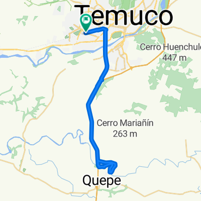
Touring the 3 highest hills around Temuco. Cerro Quemado 690mt, Cerro Pangal 774mt, Cerro Togo 630mt.
- 4 h 55 min
- Duration
- 67.2 km
- Distance
- 1,369 m
- Ascent
- 1,366 m
- Descent
- 13.7 km/h
- Avg. speed
- ---
- Max. altitude

Part of
Creadas
1 stage
Continue with Bikemap
Use, edit, or download this cycling route
You would like to ride 3 Cerros or customize it for your own trip? Here is what you can do with this Bikemap route:
Free features
- Save this route as favorite or in collections
- Copy & plan your own version of this route
- Sync your route with Garmin or Wahoo
Premium features
Free trial for 3 days, or one-time payment. More about Bikemap Premium.
- Navigate this route on iOS & Android
- Export a GPX / KML file of this route
- Create your custom printout (try it for free)
- Download this route for offline navigation
Discover more Premium features.
Get Bikemap PremiumFrom our community
Other popular routes starting in Temuco
 Cerro Ñielol Asfalto
- Distance
- 3.6 km
- Ascent
- 146 m
- Descent
- 144 m
- Location
- Temuco, Región de la Araucanía, Chile
 Vuelta al Cerro Mariposa
- Distance
- 25.5 km
- Ascent
- 239 m
- Descent
- 241 m
- Location
- Temuco, Región de la Araucanía, Chile
 3 Cerros
- Distance
- 67.2 km
- Ascent
- 1,369 m
- Descent
- 1,366 m
- Location
- Temuco, Región de la Araucanía, Chile
 Outdoor Sportlife Temuco - Parapente con Choripán
- Distance
- 19.6 km
- Ascent
- 315 m
- Descent
- 310 m
- Location
- Temuco, Región de la Araucanía, Chile
 sendero principal
- Distance
- 2.6 km
- Ascent
- 233 m
- Descent
- 61 m
- Location
- Temuco, Región de la Araucanía, Chile
 Pumalal - Monteverde 40K
- Distance
- 37.4 km
- Ascent
- 795 m
- Descent
- 795 m
- Location
- Temuco, Región de la Araucanía, Chile
 Río Quepe 2.0 - 34K, 90% asfalto
- Distance
- 34.1 km
- Ascent
- 179 m
- Descent
- 178 m
- Location
- Temuco, Región de la Araucanía, Chile
 El Álamo Express
- Distance
- 30.8 km
- Ascent
- 144 m
- Descent
- 145 m
- Location
- Temuco, Región de la Araucanía, Chile
Open it in the app