
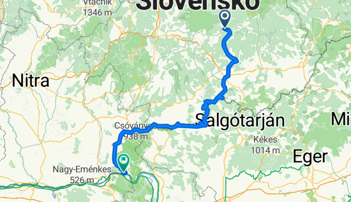
Ipoly-túra
A cycling route starting in Hriňová, Banská Bystrica Region, Slovakia.
Overview
About this route
Ipoly from the forest to the Danube
- -:--
- Duration
- 195.4 km
- Distance
- 219 m
- Ascent
- 996 m
- Descent
- ---
- Avg. speed
- ---
- Max. altitude

Route quality
Waytypes & surfaces along the route
Waytypes
Road
54.7 km
(28 %)
Quiet road
15.6 km
(8 %)
Surfaces
Paved
154.4 km
(79 %)
Unpaved
5.9 km
(3 %)
Asphalt
154.4 km
(79 %)
Ground
3.9 km
(2 %)
Continue with Bikemap
Use, edit, or download this cycling route
You would like to ride Ipoly-túra or customize it for your own trip? Here is what you can do with this Bikemap route:
Free features
- Save this route as favorite or in collections
- Copy & plan your own version of this route
- Split it into stages to create a multi-day tour
- Sync your route with Garmin or Wahoo
Premium features
Free trial for 3 days, or one-time payment. More about Bikemap Premium.
- Navigate this route on iOS & Android
- Export a GPX / KML file of this route
- Create your custom printout (try it for free)
- Download this route for offline navigation
Discover more Premium features.
Get Bikemap PremiumFrom our community
Other popular routes starting in Hriňová
 Okolo Ružinej
- Distance
- 8 km
- Ascent
- 94 m
- Descent
- 91 m
- Location
- Hriňová, Banská Bystrica Region, Slovakia
 Hore Ipľom - dole Hronom - 2. deň (verzia A)
- Distance
- 77.8 km
- Ascent
- 1,342 m
- Descent
- 1,293 m
- Location
- Hriňová, Banská Bystrica Region, Slovakia
 Hriňova, Detva , Fangov vrch, Melichová skala, Kaľamárka, Kostolna s napäť cez PPSku
- Distance
- 60.9 km
- Ascent
- 955 m
- Descent
- 955 m
- Location
- Hriňová, Banská Bystrica Region, Slovakia
 Divín-Budiná-Vrchdobroč-Kotmanová-Divín
- Distance
- 45.4 km
- Ascent
- 1,291 m
- Descent
- 1,291 m
- Location
- Hriňová, Banská Bystrica Region, Slovakia
 Školská do Partizánska
- Distance
- 46.7 km
- Ascent
- 291 m
- Descent
- 336 m
- Location
- Hriňová, Banská Bystrica Region, Slovakia
 Ipoly-túra
- Distance
- 195.4 km
- Ascent
- 219 m
- Descent
- 996 m
- Location
- Hriňová, Banská Bystrica Region, Slovakia
 Kokava Haj - okruh
- Distance
- 6.4 km
- Ascent
- 413 m
- Descent
- 419 m
- Location
- Hriňová, Banská Bystrica Region, Slovakia
 Hrinova-Polana_odPrednej-peso
- Distance
- 26.1 km
- Ascent
- 987 m
- Descent
- 987 m
- Location
- Hriňová, Banská Bystrica Region, Slovakia
Open it in the app