

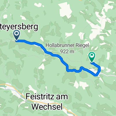
Haßbach - Koglhof - Türkenkreuz - Haßbach
A cycling route starting in Altendorf, Lower Austria, Austria.
Overview
About this route
Tourplanung - noch nicht gefahren. Teilstücke sehr steil, über Wald. Mehr nachdem ich diese Tour gefahren bin.
- -:--
- Duration
- 12 km
- Distance
- 502 m
- Ascent
- 502 m
- Descent
- ---
- Avg. speed
- ---
- Max. altitude

Continue with Bikemap
Use, edit, or download this cycling route
You would like to ride Haßbach - Koglhof - Türkenkreuz - Haßbach or customize it for your own trip? Here is what you can do with this Bikemap route:
Free features
- Save this route as favorite or in collections
- Copy & plan your own version of this route
- Sync your route with Garmin or Wahoo
Premium features
Free trial for 3 days, or one-time payment. More about Bikemap Premium.
- Navigate this route on iOS & Android
- Export a GPX / KML file of this route
- Create your custom printout (try it for free)
- Download this route for offline navigation
Discover more Premium features.
Get Bikemap PremiumFrom our community
Other popular routes starting in Altendorf
 Sonnleitenweg, Altendorf nach Oberdorfstraße, Laterns
- Distance
- 739.4 km
- Ascent
- 14,313 m
- Descent
- 14,060 m
- Location
- Altendorf, Lower Austria, Austria
 Semmering 2
- Distance
- 92.1 km
- Ascent
- 1,615 m
- Descent
- 1,615 m
- Location
- Altendorf, Lower Austria, Austria
 Gutedel am Berg - Neunkirchen
- Distance
- 12.5 km
- Ascent
- 73 m
- Descent
- 402 m
- Location
- Altendorf, Lower Austria, Austria
 Hasleiten, Feistritz am Wechsel nach Himberger Straße, Grimmenstein
- Distance
- 6.8 km
- Ascent
- 86 m
- Descent
- 203 m
- Location
- Altendorf, Lower Austria, Austria
 2. nap, Kerékpáros Maraton
- Distance
- 83.6 km
- Ascent
- 531 m
- Descent
- 1,214 m
- Location
- Altendorf, Lower Austria, Austria
 Hasleiten 10, Feistritz am Wechsel nach Buchberg 52, Buchberg bei Herberstein
- Distance
- 88 km
- Ascent
- 2,095 m
- Descent
- 2,524 m
- Location
- Altendorf, Lower Austria, Austria
 Hasleiten 28, Warth nach Vockenberg 81, Stubenberg
- Distance
- 88.8 km
- Ascent
- 2,034 m
- Descent
- 2,489 m
- Location
- Altendorf, Lower Austria, Austria
 Down to Neunkirchen
- Distance
- 13.3 km
- Ascent
- 16 m
- Descent
- 482 m
- Location
- Altendorf, Lower Austria, Austria
Open it in the app