

Eulenberg Strecke (Start Gopprechts)
A cycling route starting in Litschau, Lower Austria, Austria.
Overview
About this route
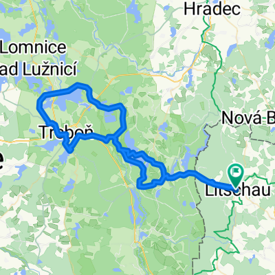
Litschau - Wielings – Gopprechts - Schlag - Josefsthal - Graselstein - Litschau
From Litschau, the route passes by the Föhrenteich pond, crossing one or another small stream until reaching Reichenbach and Wielings. Here, riders face the only notable climb, both uphill and downhill, before arriving at Gopprechts. From there, the route continues on the other side of the Reißbach heading north towards Schlag and almost to the Czech border. Passing by Josefsthal and Graselstein, the route returns back to Litschau.
- -:--
- Duration
- 35.1 km
- Distance
- 297 m
- Ascent
- 298 m
- Descent
- ---
- Avg. speed
- ---
- Max. altitude

Route quality
Waytypes & surfaces along the route
Waytypes
Track
14.4 km
(41 %)
Road
13.3 km
(38 %)
Surfaces
Paved
7 km
(20 %)
Unpaved
15.8 km
(45 %)
Gravel
9.1 km
(26 %)
Asphalt
5.3 km
(15 %)
Continue with Bikemap
Use, edit, or download this cycling route
You would like to ride Eulenberg Strecke (Start Gopprechts) or customize it for your own trip? Here is what you can do with this Bikemap route:
Free features
- Save this route as favorite or in collections
- Copy & plan your own version of this route
- Sync your route with Garmin or Wahoo
Premium features
Free trial for 3 days, or one-time payment. More about Bikemap Premium.
- Navigate this route on iOS & Android
- Export a GPX / KML file of this route
- Create your custom printout (try it for free)
- Download this route for offline navigation
Discover more Premium features.
Get Bikemap PremiumFrom our community
Other popular routes starting in Litschau
 Waldviertel Eulenberg (16)
- Distance
- 41.2 km
- Ascent
- 371 m
- Descent
- 371 m
- Location
- Litschau, Lower Austria, Austria
 Runde um Litschau
- Distance
- 38 km
- Ascent
- 482 m
- Descent
- 427 m
- Location
- Litschau, Lower Austria, Austria
 Litschau-Steinhübel-Strecke
- Distance
- 33.9 km
- Ascent
- 467 m
- Descent
- 467 m
- Location
- Litschau, Lower Austria, Austria
 zum Nordkap über CZ
- Distance
- 55.5 km
- Ascent
- 405 m
- Descent
- 405 m
- Location
- Litschau, Lower Austria, Austria
 100 Teiche Tour Litschau
- Distance
- 72.5 km
- Ascent
- 638 m
- Descent
- 638 m
- Location
- Litschau, Lower Austria, Austria
 WEM-Radrunde
- Distance
- 28.3 km
- Ascent
- 420 m
- Descent
- 416 m
- Location
- Litschau, Lower Austria, Austria
 Iron Curtain Trail 2
- Distance
- 35.2 km
- Ascent
- 523 m
- Descent
- 542 m
- Location
- Litschau, Lower Austria, Austria
 Eulenberg Strecke (Start Gopprechts)
- Distance
- 35.1 km
- Ascent
- 297 m
- Descent
- 298 m
- Location
- Litschau, Lower Austria, Austria
Open it in the app