

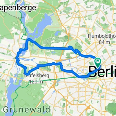
Velothon Berlin
A cycling route starting in Tiergarten, Land Berlin, Germany.
Overview
About this route
- -:--
- Duration
- 109.1 km
- Distance
- 295 m
- Ascent
- 295 m
- Descent
- ---
- Avg. speed
- 61 m
- Max. altitude
Route quality
Waytypes & surfaces along the route
Waytypes
Busy road
43.9 km
(40 %)
Cycleway
16.5 km
(15 %)
Surfaces
Paved
100.5 km
(92 %)
Unpaved
4.2 km
(4 %)
Asphalt
84.4 km
(77 %)
Paving stones
14.2 km
(13 %)
Continue with Bikemap
Use, edit, or download this cycling route
You would like to ride Velothon Berlin or customize it for your own trip? Here is what you can do with this Bikemap route:
Free features
- Save this route as favorite or in collections
- Copy & plan your own version of this route
- Split it into stages to create a multi-day tour
- Sync your route with Garmin or Wahoo
Premium features
Free trial for 3 days, or one-time payment. More about Bikemap Premium.
- Navigate this route on iOS & Android
- Export a GPX / KML file of this route
- Create your custom printout (try it for free)
- Download this route for offline navigation
Discover more Premium features.
Get Bikemap PremiumFrom our community
Other popular routes starting in Tiergarten
 Trainingsstrecke "aktivcenter"
- Distance
- 45.6 km
- Ascent
- 152 m
- Descent
- 152 m
- Location
- Tiergarten, Land Berlin, Germany
 Seddiner See
- Distance
- 115.4 km
- Ascent
- 229 m
- Descent
- 229 m
- Location
- Tiergarten, Land Berlin, Germany
 Hollys-Galeriecafe
- Distance
- 110 km
- Ascent
- 108 m
- Descent
- 111 m
- Location
- Tiergarten, Land Berlin, Germany
 D Berlin HBF-Hackescher Markt
- Distance
- 3.8 km
- Ascent
- 53 m
- Descent
- 30 m
- Location
- Tiergarten, Land Berlin, Germany
 Spree,Havel und Hohenzollernkanal
- Distance
- 33.2 km
- Ascent
- 35 m
- Descent
- 35 m
- Location
- Tiergarten, Land Berlin, Germany
 Velothon 2009
- Distance
- 122.7 km
- Ascent
- 272 m
- Descent
- 274 m
- Location
- Tiergarten, Land Berlin, Germany
 Kleine Parlamentarische Fahrradtour 2018
- Distance
- 8.8 km
- Ascent
- 56 m
- Descent
- 54 m
- Location
- Tiergarten, Land Berlin, Germany
 Mauerradweg
- Distance
- 171.7 km
- Ascent
- 169 m
- Descent
- 171 m
- Location
- Tiergarten, Land Berlin, Germany
Open it in the app