

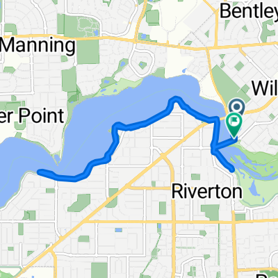
round the bridges
A cycling route starting in Wilson, Western Australia, Australia.
Overview
About this route
- 1 h 20 min
- Duration
- 18.8 km
- Distance
- 53 m
- Ascent
- 57 m
- Descent
- 14 km/h
- Avg. speed
- ---
- Avg. speed
Continue with Bikemap
Use, edit, or download this cycling route
You would like to ride round the bridges or customize it for your own trip? Here is what you can do with this Bikemap route:
Free features
- Save this route as favorite or in collections
- Copy & plan your own version of this route
- Sync your route with Garmin or Wahoo
Premium features
Free trial for 3 days, or one-time payment. More about Bikemap Premium.
- Navigate this route on iOS & Android
- Export a GPX / KML file of this route
- Create your custom printout (try it for free)
- Download this route for offline navigation
Discover more Premium features.
Get Bikemap PremiumFrom our community
Other popular routes starting in Wilson
 Kayak route Number 1
- Distance
- 6.1 km
- Ascent
- 49 m
- Descent
- 49 m
- Location
- Wilson, Western Australia, Australia
 Riverton-North Freo-UWA-Riverton Loop
- Distance
- 62.9 km
- Ascent
- 437 m
- Descent
- 439 m
- Location
- Wilson, Western Australia, Australia
 Corbel Street 60B, Shelley to Corbel Street 60B, Shelley
- Distance
- 17.1 km
- Ascent
- 3 m
- Descent
- 0 m
- Location
- Wilson, Western Australia, Australia
 The Bridges
- Distance
- 12.7 km
- Ascent
- 38 m
- Descent
- 39 m
- Location
- Wilson, Western Australia, Australia
 Short bike tour from Riverton to Murdoch
- Distance
- 8.9 km
- Ascent
- 65 m
- Descent
- 49 m
- Location
- Wilson, Western Australia, Australia
 round the bridges
- Distance
- 18.8 km
- Ascent
- 53 m
- Descent
- 57 m
- Location
- Wilson, Western Australia, Australia
 Canning walk for Michelle 1
- Distance
- 7.6 km
- Ascent
- 39 m
- Descent
- 43 m
- Location
- Wilson, Western Australia, Australia
 Easy ride in Wilson
- Distance
- 10.7 km
- Ascent
- 0 m
- Descent
- 3 m
- Location
- Wilson, Western Australia, Australia
Open it in the app