

ferrieres jour 2
A cycling route starting in Fontenay-sur-Loing, Centre-Val de Loire, France.
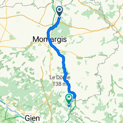
Overview
About this route
- -:--
- Duration
- 82.5 km
- Distance
- 275 m
- Ascent
- 273 m
- Descent
- ---
- Avg. speed
- ---
- Max. altitude

Route quality
Waytypes & surfaces along the route
Waytypes
Road
35.3 km
(43 %)
Quiet road
32.1 km
(39 %)
Surfaces
Paved
30 km
(36 %)
Unpaved
1 km
(1 %)
Asphalt
29.8 km
(36 %)
Ground
1 km
(1 %)
Continue with Bikemap
Use, edit, or download this cycling route
You would like to ride ferrieres jour 2 or customize it for your own trip? Here is what you can do with this Bikemap route:
Free features
- Save this route as favorite or in collections
- Copy & plan your own version of this route
- Split it into stages to create a multi-day tour
- Sync your route with Garmin or Wahoo
Premium features
Free trial for 3 days, or one-time payment. More about Bikemap Premium.
- Navigate this route on iOS & Android
- Export a GPX / KML file of this route
- Create your custom printout (try it for free)
- Download this route for offline navigation
Discover more Premium features.
Get Bikemap PremiumFrom our community
Other popular routes starting in Fontenay-sur-Loing
 ferrieres saint flo
- Distance
- 78.9 km
- Ascent
- 275 m
- Descent
- 236 m
- Location
- Fontenay-sur-Loing, Centre-Val de Loire, France
 38 Chemin des Bois, Fontenay-sur-Loing à 1–19 Rue des Lauriers, Montargis
- Distance
- 22.4 km
- Ascent
- 117 m
- Descent
- 120 m
- Location
- Fontenay-sur-Loing, Centre-Val de Loire, France
 De Maison Rouge 24, Griselles à Rue Jacques Monod 83, Olivet
- Distance
- 90 km
- Ascent
- 685 m
- Descent
- 687 m
- Location
- Fontenay-sur-Loing, Centre-Val de Loire, France
 Ferrières La Chapelle étapes 1&2
- Distance
- 103.2 km
- Ascent
- 351 m
- Descent
- 337 m
- Location
- Fontenay-sur-Loing, Centre-Val de Loire, France
 ferriere jour3
- Distance
- 81.3 km
- Ascent
- 270 m
- Descent
- 258 m
- Location
- Fontenay-sur-Loing, Centre-Val de Loire, France
 13 Route du Bignon, Ferrières-en-Gâtinais à 2 Impasse des Gaujards, Chevry-sous-le-Bignon
- Distance
- 9.4 km
- Ascent
- 62 m
- Descent
- 36 m
- Location
- Fontenay-sur-Loing, Centre-Val de Loire, France
 Avenue des Sansonnets, Nargis to 23 Rue Marceau, Chalette-Sur-Loing
- Distance
- 11.5 km
- Ascent
- 43 m
- Descent
- 32 m
- Location
- Fontenay-sur-Loing, Centre-Val de Loire, France
 Ferriers to B*B
- Distance
- 50.5 km
- Ascent
- 251 m
- Descent
- 183 m
- Location
- Fontenay-sur-Loing, Centre-Val de Loire, France
Open it in the app