

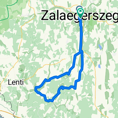
Őrségi kör
A cycling route starting in Zalaegerszeg, Zala County, Hungary.
Overview
About this route
Relatively good quality, low-traffic road. The most beautiful route in Göcsej. Climbs only in the Dobronhegy and Becsvölgy sections.
- -:--
- Duration
- 85.5 km
- Distance
- 312 m
- Ascent
- 312 m
- Descent
- ---
- Avg. speed
- ---
- Max. altitude

Route quality
Waytypes & surfaces along the route
Waytypes
Track
6 km
(7 %)
Quiet road
1.7 km
(2 %)
Surfaces
Paved
44.5 km
(52 %)
Unpaved
0.9 km
(1 %)
Asphalt
44.5 km
(52 %)
Gravel
0.9 km
(1 %)
Undefined
40.2 km
(47 %)
Route highlights
Points of interest along the route
Point of interest after 7.2 km
Kandikó, Göcsej legmagasabb pontja
Continue with Bikemap
Use, edit, or download this cycling route
You would like to ride Őrségi kör or customize it for your own trip? Here is what you can do with this Bikemap route:
Free features
- Save this route as favorite or in collections
- Copy & plan your own version of this route
- Split it into stages to create a multi-day tour
- Sync your route with Garmin or Wahoo
Premium features
Free trial for 3 days, or one-time payment. More about Bikemap Premium.
- Navigate this route on iOS & Android
- Export a GPX / KML file of this route
- Create your custom printout (try it for free)
- Download this route for offline navigation
Discover more Premium features.
Get Bikemap PremiumFrom our community
Other popular routes starting in Zalaegerszeg
 rét utca - rét utca
- Distance
- 130.3 km
- Ascent
- 604 m
- Descent
- 656 m
- Location
- Zalaegerszeg, Zala County, Hungary
 Zeg- szegek- Becsvölgye- Zeg
- Distance
- 49.5 km
- Ascent
- 475 m
- Descent
- 476 m
- Location
- Zalaegerszeg, Zala County, Hungary
 5 megyén keresztül két keréken
- Distance
- 588.2 km
- Ascent
- 525 m
- Descent
- 569 m
- Location
- Zalaegerszeg, Zala County, Hungary
 Kutyakerülő technikás
- Distance
- 44.8 km
- Ascent
- 322 m
- Descent
- 308 m
- Location
- Zalaegerszeg, Zala County, Hungary
 Boncodfölde - Rákóczi utca
- Distance
- 19.4 km
- Ascent
- 143 m
- Descent
- 163 m
- Location
- Zalaegerszeg, Zala County, Hungary
 Őrségi kör
- Distance
- 85.5 km
- Ascent
- 312 m
- Descent
- 312 m
- Location
- Zalaegerszeg, Zala County, Hungary
 11. Tag Egersee bis Jennersdorf
- Distance
- 73 km
- Ascent
- 456 m
- Descent
- 380 m
- Location
- Zalaegerszeg, Zala County, Hungary
 Route in Zalaegerszeg
- Distance
- 90.5 km
- Ascent
- 550 m
- Descent
- 543 m
- Location
- Zalaegerszeg, Zala County, Hungary
Open it in the app