

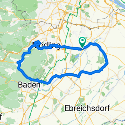
Sportliche Route in Achau
A cycling route starting in Achau, Lower Austria, Austria.
Overview
About this route
- 2 h 29 min
- Duration
- 52.5 km
- Distance
- 1,150 m
- Ascent
- 1,195 m
- Descent
- 21.2 km/h
- Avg. speed
- ---
- Max. altitude

Continue with Bikemap
Use, edit, or download this cycling route
You would like to ride Sportliche Route in Achau or customize it for your own trip? Here is what you can do with this Bikemap route:
Free features
- Save this route as favorite or in collections
- Copy & plan your own version of this route
- Sync your route with Garmin or Wahoo
Premium features
Free trial for 3 days, or one-time payment. More about Bikemap Premium.
- Navigate this route on iOS & Android
- Export a GPX / KML file of this route
- Create your custom printout (try it for free)
- Download this route for offline navigation
Discover more Premium features.
Get Bikemap PremiumFrom our community
Other popular routes starting in Achau
 Achau - Winden am See
- Distance
- 22 km
- Ascent
- 47 m
- Descent
- 40 m
- Location
- Achau, Lower Austria, Austria
 Anningergasse 2, Achau nach Bahnhofplatz 3, Bruckneudorf
- Distance
- 39.7 km
- Ascent
- 505 m
- Descent
- 495 m
- Location
- Achau, Lower Austria, Austria
 16, Achau nach Lärchengasse 33, Leopoldsdorf
- Distance
- 41.9 km
- Ascent
- 87 m
- Descent
- 69 m
- Location
- Achau, Lower Austria, Austria
 Chillige Route nach Tattendorf (Wien - Himberg fehlt), 17 kg Treckinggepäck on Board
- Distance
- 16.2 km
- Ascent
- 58 m
- Descent
- 13 m
- Location
- Achau, Lower Austria, Austria
 Kurt Stepancik-Platz 1, Achau nach Anningergasse 2, Achau
- Distance
- 93.3 km
- Ascent
- 994 m
- Descent
- 995 m
- Location
- Achau, Lower Austria, Austria
 Hennersdorfer Straße 3, Achau nach Hintausstraße 16, Achau
- Distance
- 107.5 km
- Ascent
- 1,153 m
- Descent
- 1,154 m
- Location
- Achau, Lower Austria, Austria
 Hasenrunde
- Distance
- 55.6 km
- Ascent
- 292 m
- Descent
- 294 m
- Location
- Achau, Lower Austria, Austria
 Anningergasse 2, Achau nach Doktor-Berg 99/29, Kaltenleutgeben
- Distance
- 22 km
- Ascent
- 347 m
- Descent
- 125 m
- Location
- Achau, Lower Austria, Austria
Open it in the app