
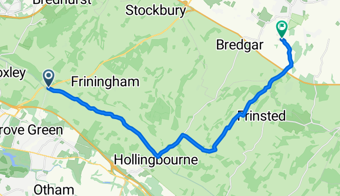
Hollingbourne Hill
A cycling route starting in Boxley, England, United Kingdom.
Overview
About this route
Hollingbourne Hill
- -:--
- Duration
- 16.6 km
- Distance
- 145 m
- Ascent
- 208 m
- Descent
- ---
- Avg. speed
- ---
- Max. altitude
Route quality
Waytypes & surfaces along the route
Waytypes
Quiet road
12.1 km
(73 %)
Road
4.5 km
(27 %)
Surfaces
Paved
13.3 km
(80 %)
Asphalt
11.4 km
(69 %)
Paved (undefined)
1.8 km
(11 %)
Undefined
3.3 km
(20 %)
Continue with Bikemap
Use, edit, or download this cycling route
You would like to ride Hollingbourne Hill or customize it for your own trip? Here is what you can do with this Bikemap route:
Free features
- Save this route as favorite or in collections
- Copy & plan your own version of this route
- Sync your route with Garmin or Wahoo
Premium features
Free trial for 3 days, or one-time payment. More about Bikemap Premium.
- Navigate this route on iOS & Android
- Export a GPX / KML file of this route
- Create your custom printout (try it for free)
- Download this route for offline navigation
Discover more Premium features.
Get Bikemap PremiumFrom our community
Other popular routes starting in Boxley
 120 miler 11 May 2014
- Distance
- 0.2 km
- Ascent
- 4 m
- Descent
- 0 m
- Location
- Boxley, England, United Kingdom
 Maidstone route
- Distance
- 60.2 km
- Ascent
- 325 m
- Descent
- 324 m
- Location
- Boxley, England, United Kingdom
 hollingbourne hill and that
- Distance
- 34.5 km
- Ascent
- 466 m
- Descent
- 468 m
- Location
- Boxley, England, United Kingdom
 ride through Chatham
- Distance
- 15.4 km
- Ascent
- 118 m
- Descent
- 173 m
- Location
- Boxley, England, United Kingdom
 Hollingbourne Hill
- Distance
- 16.6 km
- Ascent
- 145 m
- Descent
- 208 m
- Location
- Boxley, England, United Kingdom
 mtb spin
- Distance
- 5.3 km
- Ascent
- 69 m
- Descent
- 37 m
- Location
- Boxley, England, United Kingdom
 Restful route in Chatham
- Distance
- 11.6 km
- Ascent
- 273 m
- Descent
- 281 m
- Location
- Boxley, England, United Kingdom
 120 miler 11 May 2014
- Distance
- 198 km
- Ascent
- 636 m
- Descent
- 632 m
- Location
- Boxley, England, United Kingdom
Open it in the app