

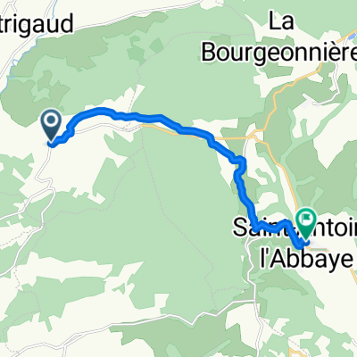
xd5-Saint Antoine
A cycling route starting in Saint-Antoine-lAbbaye, Auvergne-Rhône-Alpes, France.
Overview
About this route
- -:--
- Duration
- 96.1 km
- Distance
- 907 m
- Ascent
- 1,076 m
- Descent
- ---
- Avg. speed
- ---
- Max. altitude

Route quality
Waytypes & surfaces along the route
Waytypes
Quiet road
50.9 km
(53 %)
Road
27.9 km
(29 %)
Surfaces
Paved
15.4 km
(16 %)
Unpaved
5.8 km
(6 %)
Asphalt
15.4 km
(16 %)
Gravel
2.9 km
(3 %)
Continue with Bikemap
Use, edit, or download this cycling route
You would like to ride xd5-Saint Antoine or customize it for your own trip? Here is what you can do with this Bikemap route:
Free features
- Save this route as favorite or in collections
- Copy & plan your own version of this route
- Split it into stages to create a multi-day tour
- Sync your route with Garmin or Wahoo
Premium features
Free trial for 3 days, or one-time payment. More about Bikemap Premium.
- Navigate this route on iOS & Android
- Export a GPX / KML file of this route
- Create your custom printout (try it for free)
- Download this route for offline navigation
Discover more Premium features.
Get Bikemap PremiumFrom our community
Other popular routes starting in Saint-Antoine-lAbbaye
 Aux Reynauds 985, Saint-Antoine-l'Abbaye to Grande Rue 156, Saint-Antoine-l'Abbaye
- Distance
- 2.2 km
- Ascent
- 23 m
- Descent
- 212 m
- Location
- Saint-Antoine-lAbbaye, Auvergne-Rhône-Alpes, France
 De 300 Grande Rue, Saint-Antoine-l'Abbaye à 10 Route du Chalon, Saint-Bonnet-de-Valclérieux
- Distance
- 8.6 km
- Ascent
- 211 m
- Descent
- 178 m
- Location
- Saint-Antoine-lAbbaye, Auvergne-Rhône-Alpes, France
 xd5-Saint Antoine
- Distance
- 96.1 km
- Ascent
- 907 m
- Descent
- 1,076 m
- Location
- Saint-Antoine-lAbbaye, Auvergne-Rhône-Alpes, France
 Les Allamands, Montmiral à 365 Route des Antonins, Parnans
- Distance
- 5.9 km
- Ascent
- 64 m
- Descent
- 92 m
- Location
- Saint-Antoine-lAbbaye, Auvergne-Rhône-Alpes, France
 zondag
- Distance
- 112.2 km
- Ascent
- 1,531 m
- Descent
- 1,451 m
- Location
- Saint-Antoine-lAbbaye, Auvergne-Rhône-Alpes, France
 50 Chemin des Bonnes Matées, Saint-Bonnet-de-Valclérieux à D27, Dionay
- Distance
- 4 km
- Ascent
- 80 m
- Descent
- 40 m
- Location
- Saint-Antoine-lAbbaye, Auvergne-Rhône-Alpes, France
 De 10 Route du Chalon, Saint-Bonnet-de-Valclérieux à 173 Grande Rue, Saint-Antoine-l'Abbaye
- Distance
- 8.7 km
- Ascent
- 174 m
- Descent
- 210 m
- Location
- Saint-Antoine-lAbbaye, Auvergne-Rhône-Alpes, France
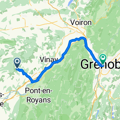 StAntoine-Grenoble
- Distance
- 64.5 km
- Ascent
- 269 m
- Descent
- 410 m
- Location
- Saint-Antoine-lAbbaye, Auvergne-Rhône-Alpes, France
Open it in the app