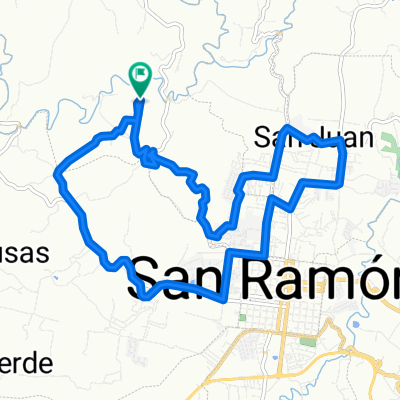
Paseo lento en Costa Rica
A cycling route starting in San Ram贸n, Alajuela Province, Costa Rica.
Overview
About this route
- 1 h 21 min
- Duration
- 17 km
- Distance
- 655 m
- Ascent
- 621 m
- Descent
- 12.5 km/h
- Avg. speed
- ---
- Max. altitude
Route quality
Waytypes & surfaces along the route
Waytypes
Road
8.6 km
(50 %)
Quiet road
8.4 km
(49 %)
Surfaces
Paved
4 km
(23 %)
Paved (undefined)
3.6 km
(21 %)
Asphalt
0.3 km
(2 %)
Undefined
13.1 km
(77 %)
Continue with Bikemap
Use, edit, or download this cycling route
You would like to ride Paseo lento en Costa Rica or customize it for your own trip? Here is what you can do with this Bikemap route:
Free features
- Save this route as favorite or in collections
- Copy & plan your own version of this route
- Sync your route with Garmin or Wahoo
Premium features
Free trial for 3 days, or one-time payment. More about Bikemap Premium.
- Navigate this route on iOS & Android
- Export a GPX / KML file of this route
- Create your custom printout (try it for free)
- Download this route for offline navigation
Discover more Premium features.
Get Bikemap PremiumFrom our community
Other popular routes starting in San Ram贸n
- San Ramon, Naranjo, cruce de Zarcero San Ramon
- Distance
- 48.4 km
- Ascent
- 932 m
- Descent
- 931 m
- Location
- San Ram贸n, Alajuela Province, Costa Rica
- San Ram贸n
- Distance
- 80.4 km
- Ascent
- 991 m
- Descent
- 916 m
- Location
- San Ram贸n, Alajuela Province, Costa Rica
- Tour San Pedro-Los Angeles
- Distance
- 20.1 km
- Ascent
- 529 m
- Descent
- 527 m
- Location
- San Ram贸n, Alajuela Province, Costa Rica
- cerro Azahar
- Distance
- 37.8 km
- Ascent
- 873 m
- Descent
- 878 m
- Location
- San Ram贸n, Alajuela Province, Costa Rica
- Paseo r谩pido en San Ram贸n
- Distance
- 20.5 km
- Ascent
- 656 m
- Descent
- 654 m
- Location
- San Ram贸n, Alajuela Province, Costa Rica
- Ruta escondida Palmares
- Distance
- 16.1 km
- Ascent
- 433 m
- Descent
- 435 m
- Location
- San Ram贸n, Alajuela Province, Costa Rica
- Palmares ruta escondida
- Distance
- 8.8 km
- Ascent
- 239 m
- Descent
- 277 m
- Location
- San Ram贸n, Alajuela Province, Costa Rica
- EL PASO DEL TIGRE
- Distance
- 36.1 km
- Ascent
- 847 m
- Descent
- 846 m
- Location
- San Ram贸n, Alajuela Province, Costa Rica
Open it in the app