

B2B00471 Via Park Ave
A cycling route starting in Richfield, Minnesota, United States.
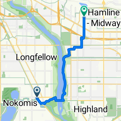
Overview
About this route
Use Portland for the homebound leg.
- -:--
- Duration
- 14.7 km
- Distance
- 18 m
- Ascent
- 12 m
- Descent
- ---
- Avg. speed
- 265 m
- Max. altitude
Route quality
Waytypes & surfaces along the route
Waytypes
Road
7.2 km
(49 %)
Quiet road
6.9 km
(47 %)
Surfaces
Paved
4 km
(27 %)
Asphalt
3.8 km
(26 %)
Paved (undefined)
0.1 km
(1 %)
Undefined
10.8 km
(73 %)
Continue with Bikemap
Use, edit, or download this cycling route
You would like to ride B2B00471 Via Park Ave or customize it for your own trip? Here is what you can do with this Bikemap route:
Free features
- Save this route as favorite or in collections
- Copy & plan your own version of this route
- Sync your route with Garmin or Wahoo
Premium features
Free trial for 3 days, or one-time payment. More about Bikemap Premium.
- Navigate this route on iOS & Android
- Export a GPX / KML file of this route
- Create your custom printout (try it for free)
- Download this route for offline navigation
Discover more Premium features.
Get Bikemap PremiumFrom our community
Other popular routes starting in Richfield
 B2B00920 55407>55438 via Portland, Mnnha Pwy, Logan, Hylund Prk
- Distance
- 23.7 km
- Ascent
- 98 m
- Descent
- 95 m
- Location
- Richfield, Minnesota, United States
 Route to Headflyer Brewing
- Distance
- 9.1 km
- Ascent
- 100 m
- Descent
- 69 m
- Location
- Richfield, Minnesota, United States
 the Bike & Bistro's premiere tour
- Distance
- 6.7 km
- Ascent
- 26 m
- Descent
- 9 m
- Location
- Richfield, Minnesota, United States
 East 46th Street 180, Minneapolis to Union Depot, Saint Paul
- Distance
- 22.2 km
- Ascent
- 153 m
- Descent
- 185 m
- Location
- Richfield, Minnesota, United States
 B2B00056 55407>55122 via Mnnhaha Pwy, Bg Rvrs Trl
- Distance
- 17.7 km
- Ascent
- 99 m
- Descent
- 109 m
- Location
- Richfield, Minnesota, United States
 B2B00001 55419 > 55416 via Lake Harriet, 38th, France
- Distance
- 8.4 km
- Ascent
- 75 m
- Descent
- 76 m
- Location
- Richfield, Minnesota, United States
 B2B00042 55419 > 55422 via Greenway, Cedar Lake, and Theo Wirth
- Distance
- 13.3 km
- Ascent
- 61 m
- Descent
- 59 m
- Location
- Richfield, Minnesota, United States
 Day 1 Lag 3
- Distance
- 106.3 km
- Ascent
- 327 m
- Descent
- 359 m
- Location
- Richfield, Minnesota, United States
Open it in the app