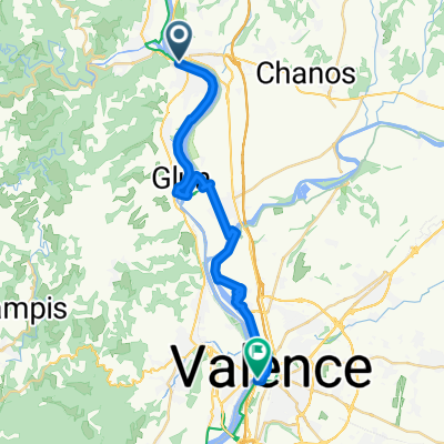
Route in Tain l'Hermitage
A cycling route starting in Tournon-sur-Rh么ne, Auvergne-Rh么ne-Alpes, France.
Overview
About this route
- 5 h 28 min
- Duration
- 34.4 km
- Distance
- 3,482 m
- Ascent
- 3,493 m
- Descent
- 6.3 km/h
- Avg. speed
- ---
- Avg. speed
Route photos
Route quality
Waytypes & surfaces along the route
Waytypes
Quiet road
21.2 km
(62 %)
Track
5.7 km
(17 %)
Surfaces
Paved
7.4 km
(22 %)
Unpaved
3.1 km
(9 %)
Asphalt
6.3 km
(18 %)
Unpaved (undefined)
1.7 km
(5 %)
Continue with Bikemap
Use, edit, or download this cycling route
You would like to ride Route in Tain l'Hermitage or customize it for your own trip? Here is what you can do with this Bikemap route:
Free features
- Save this route as favorite or in collections
- Copy & plan your own version of this route
- Sync your route with Garmin or Wahoo
Premium features
Free trial for 3 days, or one-time payment. More about Bikemap Premium.
- Navigate this route on iOS & Android
- Export a GPX / KML file of this route
- Create your custom printout (try it for free)
- Download this route for offline navigation
Discover more Premium features.
Get Bikemap PremiumFrom our community
Other popular routes starting in Tournon-sur-Rh么ne
- RW25-W2-ab-Schiff_Sur les Pas de Gambert 脿 Tain-l'Hermitage
- Distance
- 6.8 km
- Ascent
- 259 m
- Descent
- 261 m
- Location
- Tournon-sur-Rh么ne, Auvergne-Rh么ne-Alpes, France
- De Avenue Mar茅chal Foch 13, Tournon-sur-Rh么ne 脿 Rue Emile Vivion 112, Tain-l'Hermitage
- Distance
- 8.1 km
- Ascent
- 45 m
- Descent
- 51 m
- Location
- Tournon-sur-Rh么ne, Auvergne-Rh么ne-Alpes, France
- Hendaye-Tain-l'Hermitage
- Distance
- 886.9 km
- Ascent
- 3,178 m
- Descent
- 3,282 m
- Location
- Tournon-sur-Rh么ne, Auvergne-Rh么ne-Alpes, France
- CrozesHermitagerunde9.5km
- Distance
- 9.5 km
- Ascent
- 124 m
- Descent
- 129 m
- Location
- Tournon-sur-Rh么ne, Auvergne-Rh么ne-Alpes, France
- Day 2 ( reworked))
- Distance
- 77.6 km
- Ascent
- 136 m
- Descent
- 170 m
- Location
- Tournon-sur-Rh么ne, Auvergne-Rh么ne-Alpes, France
- Route in Tain l'Hermitage
- Distance
- 34.4 km
- Ascent
- 3,482 m
- Descent
- 3,493 m
- Location
- Tournon-sur-Rh么ne, Auvergne-Rh么ne-Alpes, France
- Tournon St Vallier et retour par Larnage
- Distance
- 37 km
- Ascent
- 272 m
- Descent
- 269 m
- Location
- Tournon-sur-Rh么ne, Auvergne-Rh么ne-Alpes, France
- Via Rh么na:3猫me Etappe Tournon 脿 Valence
- Distance
- 24.7 km
- Ascent
- 47 m
- Descent
- 34 m
- Location
- Tournon-sur-Rh么ne, Auvergne-Rh么ne-Alpes, France
Open it in the app