

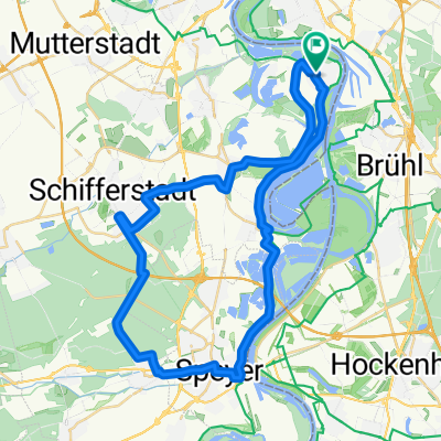
rijn-route 8
A cycling route starting in Altrip, Rhineland-Palatinate, Germany.
Overview
About this route
- -:--
- Duration
- 94.6 km
- Distance
- 613 m
- Ascent
- 545 m
- Descent
- ---
- Avg. speed
- 361 m
- Max. altitude

Route quality
Waytypes & surfaces along the route
Waytypes
Quiet road
27.5 km
(29 %)
Track
22.9 km
(24 %)
Surfaces
Paved
81.3 km
(86 %)
Unpaved
5.9 km
(6 %)
Asphalt
74.6 km
(79 %)
Gravel
5.6 km
(6 %)
Continue with Bikemap
Use, edit, or download this cycling route
You would like to ride rijn-route 8 or customize it for your own trip? Here is what you can do with this Bikemap route:
Free features
- Save this route as favorite or in collections
- Copy & plan your own version of this route
- Split it into stages to create a multi-day tour
- Sync your route with Garmin or Wahoo
Premium features
Free trial for 3 days, or one-time payment. More about Bikemap Premium.
- Navigate this route on iOS & Android
- Export a GPX / KML file of this route
- Create your custom printout (try it for free)
- Download this route for offline navigation
Discover more Premium features.
Get Bikemap PremiumFrom our community
Other popular routes starting in Altrip
 Altrip-Schifferstadt-Haßloch-Geinsheim-Dudenhofen-Speyer-Altrip CLONED FROM ROUTE 262025
- Distance
- 62.4 km
- Ascent
- 67 m
- Descent
- 68 m
- Location
- Altrip, Rhineland-Palatinate, Germany
 Apfelblütenweg
- Distance
- 46.2 km
- Ascent
- 315 m
- Descent
- 317 m
- Location
- Altrip, Rhineland-Palatinate, Germany
 Altrip-Speyer-Dudenhofen-Waldsee-Altrip CLONED FROM ROUTE 21934
- Distance
- 44.3 km
- Ascent
- 50 m
- Descent
- 50 m
- Location
- Altrip, Rhineland-Palatinate, Germany
 Weißer Stein - Langenthal - Rothenberg - Rippenweier
- Distance
- 97.3 km
- Ascent
- 1,755 m
- Descent
- 1,755 m
- Location
- Altrip, Rhineland-Palatinate, Germany
 Rheinau - Altrip - Brühl
- Distance
- 29.5 km
- Ascent
- 80 m
- Descent
- 80 m
- Location
- Altrip, Rhineland-Palatinate, Germany
 Neckarau Altrip Speyer Wörth Straßburg links
- Distance
- 153.3 km
- Ascent
- 111 m
- Descent
- 59 m
- Location
- Altrip, Rhineland-Palatinate, Germany
 Durch den Rheinauer Wald
- Distance
- 8.9 km
- Ascent
- 40 m
- Descent
- 40 m
- Location
- Altrip, Rhineland-Palatinate, Germany
 Mannheim -Ketsch-Speyer-Altrip-Mannheim
- Distance
- 60.1 km
- Ascent
- 85 m
- Descent
- 83 m
- Location
- Altrip, Rhineland-Palatinate, Germany
Open it in the app