
Home - Collingwood training
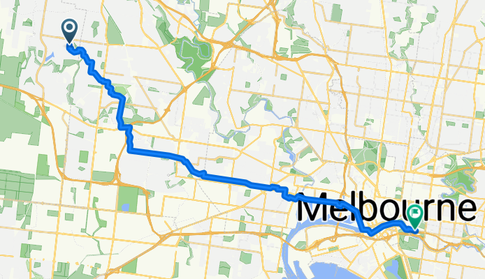
A cycling route starting in Burnside Heights, Victoria, Australia.
Overview
About this route
- 1 h 41 min
- Duration
- 29.8 km
- Distance
- 157 m
- Ascent
- 233 m
- Descent
- 17.8 km/h
- Avg. speed
- ---
- Max. altitude
Route quality
Waytypes & surfaces along the route
Waytypes
Cycleway
14 km
(47 %)
Quiet road
6.5 km
(22 %)
Surfaces
Paved
23.3 km
(78 %)
Unpaved
0.1 km
(<1 %)
Asphalt
10.2 km
(34 %)
Concrete
8.3 km
(28 %)
Continue with Bikemap
Use, edit, or download this cycling route
You would like to ride Home - Collingwood training or customize it for your own trip? Here is what you can do with this Bikemap route:
Free features
- Save this route as favorite or in collections
- Copy & plan your own version of this route
- Sync your route with Garmin or Wahoo
Premium features
Free trial for 3 days, or one-time payment. More about Bikemap Premium.
- Navigate this route on iOS & Android
- Export a GPX / KML file of this route
- Create your custom printout (try it for free)
- Download this route for offline navigation
Discover more Premium features.
Get Bikemap PremiumFrom our community
Other popular routes starting in Burnside Heights
 ST KILDA BEACH FROM CAROLINE SPRINGS VIA TRAIL
- Distance
- 65.1 km
- Ascent
- 103 m
- Descent
- 103 m
- Location
- Burnside Heights, Victoria, Australia
 Gourlay Road,Stony hill creek,Kororoit creek
- Distance
- 16.2 km
- Ascent
- 66 m
- Descent
- 63 m
- Location
- Burnside Heights, Victoria, Australia
 Hawksbury Green 5, Caroline Springs to Lawson Way 8, Caroline Springs
- Distance
- 25.3 km
- Ascent
- 128 m
- Descent
- 120 m
- Location
- Burnside Heights, Victoria, Australia
 Route to Burnside Heights
- Distance
- 11.5 km
- Ascent
- 36 m
- Descent
- 37 m
- Location
- Burnside Heights, Victoria, Australia
 11 Dahlia Drive, Caroline Springs to 11 Dahlia Drive, Caroline Springs
- Distance
- 9.3 km
- Ascent
- 45 m
- Descent
- 45 m
- Location
- Burnside Heights, Victoria, Australia
 11 Dahlia Drive, Caroline Springs to 11 Dahlia Drive, Caroline Springs
- Distance
- 4 km
- Ascent
- 16 m
- Descent
- 16 m
- Location
- Burnside Heights, Victoria, Australia
 42 Inglewood Drive, Burnside Heights to 42 Inglewood Drive, Burnside Heights
- Distance
- 0.1 km
- Ascent
- 0 m
- Descent
- 0 m
- Location
- Burnside Heights, Victoria, Australia
 Taylors Hill to Kororoit Creek Trail, Sunshine West
- Distance
- 32.3 km
- Ascent
- 67 m
- Descent
- 65 m
- Location
- Burnside Heights, Victoria, Australia
Open it in the app