

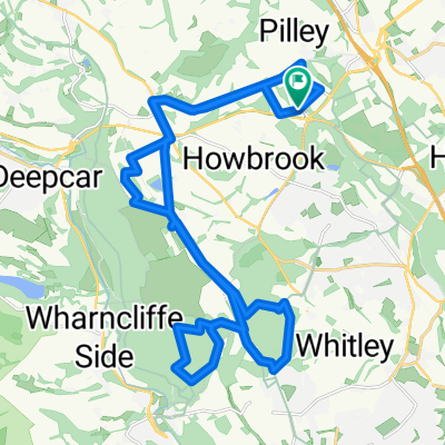
Muddy Tpt east then roads back
A cycling route starting in Wortley, England, United Kingdom.
Overview
About this route
- 1 h 54 min
- Duration
- 27.7 km
- Distance
- 910 m
- Ascent
- 826 m
- Descent
- 14.6 km/h
- Avg. speed
- ---
- Max. altitude

Route quality
Waytypes & surfaces along the route
Waytypes
Road
7.7 km
(28 %)
Quiet road
7.6 km
(27 %)
Surfaces
Paved
10.1 km
(36 %)
Unpaved
1.9 km
(7 %)
Asphalt
10 km
(36 %)
Gravel
1.8 km
(7 %)
Continue with Bikemap
Use, edit, or download this cycling route
You would like to ride Muddy Tpt east then roads back or customize it for your own trip? Here is what you can do with this Bikemap route:
Free features
- Save this route as favorite or in collections
- Copy & plan your own version of this route
- Sync your route with Garmin or Wahoo
Premium features
Free trial for 3 days, or one-time payment. More about Bikemap Premium.
- Navigate this route on iOS & Android
- Export a GPX / KML file of this route
- Create your custom printout (try it for free)
- Download this route for offline navigation
Discover more Premium features.
Get Bikemap PremiumFrom our community
Other popular routes starting in Wortley
 Thurgoland to Dunford Bridge and back Dec 2018
- Distance
- 30.1 km
- Ascent
- 303 m
- Descent
- 293 m
- Location
- Wortley, England, United Kingdom
 Wortley Cycling
- Distance
- 25.9 km
- Ascent
- 512 m
- Descent
- 508 m
- Location
- Wortley, England, United Kingdom
 Wortley Cycling
- Distance
- 6.5 km
- Ascent
- 48 m
- Descent
- 72 m
- Location
- Wortley, England, United Kingdom
 1–99 Fairfield, Thurgoland, Sheffield to 1–99 Fairfield, Thurgoland, Sheffield
- Distance
- 13.8 km
- Ascent
- 117 m
- Descent
- 118 m
- Location
- Wortley, England, United Kingdom
 Park Ave, Wortley, Sheffield to 30 Old House Close, Barnsley
- Distance
- 11.6 km
- Ascent
- 111 m
- Descent
- 262 m
- Location
- Wortley, England, United Kingdom
 last of the........
- Distance
- 31 km
- Ascent
- 664 m
- Descent
- 358 m
- Location
- Wortley, England, United Kingdom
 Thurgoland to Dunford Bridge Car Park/Windle Edge
- Distance
- 15.5 km
- Ascent
- 219 m
- Descent
- 133 m
- Location
- Wortley, England, United Kingdom
 Maple Court, Tankersley to Maple Court, Tankersley
- Distance
- 28.3 km
- Ascent
- 409 m
- Descent
- 416 m
- Location
- Wortley, England, United Kingdom
Open it in the app