

E-Bike Genusstour
A cycling route starting in Sankt Ruprecht an der Raab, Styria, Austria.
Overview
About this route
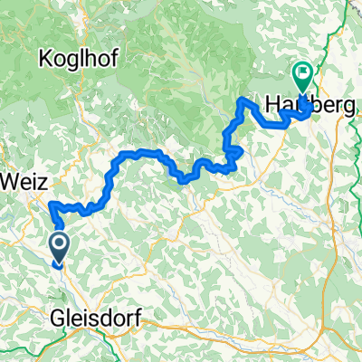
The 160-kilometer cycling tour takes you from St. Ruprecht/Raab via Passail, St. Kathrein/Offenegg, Anger, Stubenberg, Hofkrichen, Pöllau, Bad Waltersdorf and back to St. Ruprecht/Raab. As the tour suggests, there is much to enjoy during the ride. Not only the impressive landscapes but also the culinary destinations along the way are worth a visit.
- -:--
- Duration
- 146.9 km
- Distance
- 2,527 m
- Ascent
- 2,527 m
- Descent
- ---
- Avg. speed
- ---
- Max. altitude

Route quality
Waytypes & surfaces along the route
Waytypes
Quiet road
72 km
(49 %)
Road
25 km
(17 %)
Surfaces
Paved
67.6 km
(46 %)
Unpaved
13.2 km
(9 %)
Asphalt
64.6 km
(44 %)
Gravel
7.3 km
(5 %)
Continue with Bikemap
Use, edit, or download this cycling route
You would like to ride E-Bike Genusstour or customize it for your own trip? Here is what you can do with this Bikemap route:
Free features
- Save this route as favorite or in collections
- Copy & plan your own version of this route
- Split it into stages to create a multi-day tour
- Sync your route with Garmin or Wahoo
Premium features
Free trial for 3 days, or one-time payment. More about Bikemap Premium.
- Navigate this route on iOS & Android
- Export a GPX / KML file of this route
- Create your custom printout (try it for free)
- Download this route for offline navigation
Discover more Premium features.
Get Bikemap PremiumFrom our community
Other popular routes starting in Sankt Ruprecht an der Raab
 Parkstraße 112, St. Ruprecht an der Raab nach Parkstraße 12, St. Ruprecht an der Raab
- Distance
- 68.2 km
- Ascent
- 1,410 m
- Descent
- 1,414 m
- Location
- Sankt Ruprecht an der Raab, Styria, Austria
 Käferbohnentour für Familien
- Distance
- 21.8 km
- Ascent
- 248 m
- Descent
- 247 m
- Location
- Sankt Ruprecht an der Raab, Styria, Austria
 Ilztal Tour
- Distance
- 40.8 km
- Ascent
- 578 m
- Descent
- 581 m
- Location
- Sankt Ruprecht an der Raab, Styria, Austria
 St. Ruprecht - Gleisdorf - Prebuch
- Distance
- 27.6 km
- Ascent
- 297 m
- Descent
- 298 m
- Location
- Sankt Ruprecht an der Raab, Styria, Austria
 05 - St. Ruprecht - Hartberg
- Distance
- 56.9 km
- Ascent
- 840 m
- Descent
- 638 m
- Location
- Sankt Ruprecht an der Raab, Styria, Austria
 Ehrenbergstraße, Eggersdorf nach Hauptstraße, Laßnitzhöhe
- Distance
- 16.4 km
- Ascent
- 335 m
- Descent
- 330 m
- Location
- Sankt Ruprecht an der Raab, Styria, Austria
 E-Bike Genusstour
- Distance
- 146.9 km
- Ascent
- 2,527 m
- Descent
- 2,527 m
- Location
- Sankt Ruprecht an der Raab, Styria, Austria
 Grazer Hügelland Tour
- Distance
- 49.5 km
- Ascent
- 876 m
- Descent
- 878 m
- Location
- Sankt Ruprecht an der Raab, Styria, Austria
Open it in the app