Filipka
- 14 km
- 423 m
- 88 m
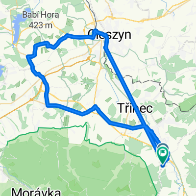
- Třinec, Moravskoslezský kraj, Czechia
A cycling route starting in Třinec, Moravskoslezský kraj, Czechia.
Overview
On this route, cyclists will enjoy a relaxing ride through the countryside, a great MTB ascent to Prašivá and Kotař, with a descent to Morávka. Then we set off to Slavíč and further to Chata Kamenitý, from where we will descend before the last ascent to Skalka.
created this 15 years ago
Route quality
Quiet road
22 km
(38 %)
Track
22 km
(38 %)
Paved
20.8 km
(36 %)
Unpaved
10.4 km
(18 %)
Asphalt
12.2 km
(21 %)
Paved (undefined)
8.7 km
(15 %)
Route highlights
Prašivá
Hospoda Galerie
Restaurace u Splavu
Slavíč
Chata Kamenitý
Skalka
Continue with Bikemap
You would like to ride 1a - pro velmi zdatné cyklisty or customize it for your own trip? Here is what you can do with this Bikemap route:
Free trial for 3 days, or one-time payment. More about Bikemap Premium.
Discover more Premium features.
Get Bikemap PremiumFrom our community
Open it in the app