

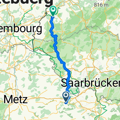
Etappe 5
A cycling route starting in Saint-Avold, Grand Est, France.
Overview
About this route
Deel van reis van Maastricht naar Selestat.
Groen, weinig verkeer
- -:--
- Duration
- 75.7 km
- Distance
- 437 m
- Ascent
- 434 m
- Descent
- ---
- Avg. speed
- ---
- Max. altitude
Route quality
Waytypes & surfaces along the route
Waytypes
Busy road
54.4 km
(72 %)
Quiet road
6.4 km
(8 %)
Surfaces
Paved
57.5 km
(76 %)
Unpaved
2.6 km
(3 %)
Asphalt
57.4 km
(76 %)
Gravel
1.6 km
(2 %)
Continue with Bikemap
Use, edit, or download this cycling route
You would like to ride Etappe 5 or customize it for your own trip? Here is what you can do with this Bikemap route:
Free features
- Save this route as favorite or in collections
- Copy & plan your own version of this route
- Sync your route with Garmin or Wahoo
Premium features
Free trial for 3 days, or one-time payment. More about Bikemap Premium.
- Navigate this route on iOS & Android
- Export a GPX / KML file of this route
- Create your custom printout (try it for free)
- Download this route for offline navigation
Discover more Premium features.
Get Bikemap PremiumFrom our community
Other popular routes starting in Saint-Avold
 De Rue de l'Ermitage, Saint-Avold à Rue de l'Ermitage, Saint-Avold
- Distance
- 17.3 km
- Ascent
- 167 m
- Descent
- 165 m
- Location
- Saint-Avold, Grand Est, France
 De Rue de l'Ermitage, Saint-Avold à Rue de l'Ermitage, Saint-Avold
- Distance
- 14 km
- Ascent
- 133 m
- Descent
- 141 m
- Location
- Saint-Avold, Grand Est, France
 De 1 Passage des Poilus, Saint-Avold à Michael-Scherer-Straße, Konz
- Distance
- 89.5 km
- Ascent
- 304 m
- Descent
- 403 m
- Location
- Saint-Avold, Grand Est, France
 Edelweiss
- Distance
- 9.6 km
- Ascent
- 154 m
- Descent
- 152 m
- Location
- Saint-Avold, Grand Est, France
 Böhl-Iggelheim - Wahagnies 2. Etappe
- Distance
- 126.7 km
- Ascent
- 594 m
- Descent
- 632 m
- Location
- Saint-Avold, Grand Est, France
 Rue de l'Ermitage, Saint-Avold to Rue de l'Ermitage, Saint-Avold
- Distance
- 24 km
- Ascent
- 350 m
- Descent
- 335 m
- Location
- Saint-Avold, Grand Est, France
 Day5
Day5- Distance
- 97.3 km
- Ascent
- 556 m
- Descent
- 552 m
- Location
- Saint-Avold, Grand Est, France
 De Rue de l'Ermitage, Saint-Avold à Rue de l'Ermitage, Saint-Avold
- Distance
- 22.4 km
- Ascent
- 398 m
- Descent
- 396 m
- Location
- Saint-Avold, Grand Est, France
Open it in the app