

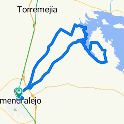
II MARCHA NOCTURNA EN BTT
A cycling route starting in Almendralejo, Extremadura, Spain.
Overview
About this route
II night march of the association GRUPO VERDE DE ALMENDRALEJO EN BTT
- -:--
- Duration
- 93.4 km
- Distance
- 255 m
- Ascent
- 255 m
- Descent
- ---
- Avg. speed
- ---
- Max. altitude

Route highlights
Points of interest along the route
Point of interest after 40.5 km
Parada a cenar
Point of interest after 51.9 km
Descanso de no más de 60 minutos
Point of interest after 67.9 km
Descanso
Point of interest after 81 km
Descanso
Continue with Bikemap
Use, edit, or download this cycling route
You would like to ride II MARCHA NOCTURNA EN BTT or customize it for your own trip? Here is what you can do with this Bikemap route:
Free features
- Save this route as favorite or in collections
- Copy & plan your own version of this route
- Split it into stages to create a multi-day tour
- Sync your route with Garmin or Wahoo
Premium features
Free trial for 3 days, or one-time payment. More about Bikemap Premium.
- Navigate this route on iOS & Android
- Export a GPX / KML file of this route
- Create your custom printout (try it for free)
- Download this route for offline navigation
Discover more Premium features.
Get Bikemap PremiumFrom our community
Other popular routes starting in Almendralejo
 Pantano de Alange por el Morgaño
- Distance
- 41.5 km
- Ascent
- 197 m
- Descent
- 195 m
- Location
- Almendralejo, Extremadura, Spain
 Los Pajares
- Distance
- 32.6 km
- Ascent
- 151 m
- Descent
- 151 m
- Location
- Almendralejo, Extremadura, Spain
 Ruta el Morgaño
- Distance
- 45.4 km
- Ascent
- 165 m
- Descent
- 165 m
- Location
- Almendralejo, Extremadura, Spain
 Paseo Por el Pantano de Villalba
- Distance
- 46 km
- Ascent
- 336 m
- Descent
- 335 m
- Location
- Almendralejo, Extremadura, Spain
 Caminos don Sancho y Huseros
- Distance
- 40.8 km
- Ascent
- 274 m
- Descent
- 254 m
- Location
- Almendralejo, Extremadura, Spain
 GRUPO VERDE: PUEBLOS, ACEUCHAL
- Distance
- 28.9 km
- Ascent
- 186 m
- Descent
- 184 m
- Location
- Almendralejo, Extremadura, Spain
 Almendralejo-Los Pajares
- Distance
- 36.2 km
- Ascent
- 150 m
- Descent
- 168 m
- Location
- Almendralejo, Extremadura, Spain
 El Manzo
- Distance
- 36.7 km
- Ascent
- 201 m
- Descent
- 190 m
- Location
- Almendralejo, Extremadura, Spain
Open it in the app