

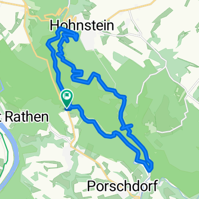
Hohnstein -Kirnitzschtal-Königstein
A cycling route starting in Hohnstein, Saxony, Germany.
Overview
About this route
8:10/9:10 with BUS 237 from Pirna to Hohenstein
–Hohenstein-Lichtenhain-Bad Schandau-Fortress Königstein-Rathen-Wehlen-Pirna (ELBE CYCLE ROUTE)
- -:--
- Duration
- 52.5 km
- Distance
- 484 m
- Ascent
- 653 m
- Descent
- ---
- Avg. speed
- ---
- Max. altitude

Route quality
Waytypes & surfaces along the route
Waytypes
Quiet road
15.8 km
(30 %)
Access road
9.5 km
(18 %)
Surfaces
Paved
47.3 km
(90 %)
Unpaved
1.6 km
(3 %)
Asphalt
47.3 km
(90 %)
Gravel
1.1 km
(2 %)
Continue with Bikemap
Use, edit, or download this cycling route
You would like to ride Hohnstein -Kirnitzschtal-Königstein or customize it for your own trip? Here is what you can do with this Bikemap route:
Free features
- Save this route as favorite or in collections
- Copy & plan your own version of this route
- Sync your route with Garmin or Wahoo
Premium features
Free trial for 3 days, or one-time payment. More about Bikemap Premium.
- Navigate this route on iOS & Android
- Export a GPX / KML file of this route
- Create your custom printout (try it for free)
- Download this route for offline navigation
Discover more Premium features.
Get Bikemap PremiumFrom our community
Other popular routes starting in Hohnstein
 MTB Wesenitz
- Distance
- 32.1 km
- Ascent
- 503 m
- Descent
- 513 m
- Location
- Hohnstein, Saxony, Germany
 Elberadweg in CZ; then back through northern CZ
- Distance
- 589.5 km
- Ascent
- 1,136 m
- Descent
- 1,137 m
- Location
- Hohnstein, Saxony, Germany
 Bei Rathen
- Distance
- 4.6 km
- Ascent
- 264 m
- Descent
- 262 m
- Location
- Hohnstein, Saxony, Germany
 rathen hohenstein polenztal rathen
- Distance
- 14.3 km
- Ascent
- 449 m
- Descent
- 449 m
- Location
- Hohnstein, Saxony, Germany
 Rundtour Felsschluchten Kurort Rathen
- Distance
- 12.5 km
- Ascent
- 402 m
- Descent
- 393 m
- Location
- Hohnstein, Saxony, Germany
 Geb.-wandern mit Wanderlust 25.02.
- Distance
- 15 km
- Ascent
- 475 m
- Descent
- 472 m
- Location
- Hohnstein, Saxony, Germany
 Polenztal zur Gautschgrotte
- Distance
- 14.5 km
- Ascent
- 362 m
- Descent
- 363 m
- Location
- Hohnstein, Saxony, Germany
 Hirschgrund Griesgrund
- Distance
- 6.8 km
- Ascent
- 251 m
- Descent
- 251 m
- Location
- Hohnstein, Saxony, Germany
Open it in the app