

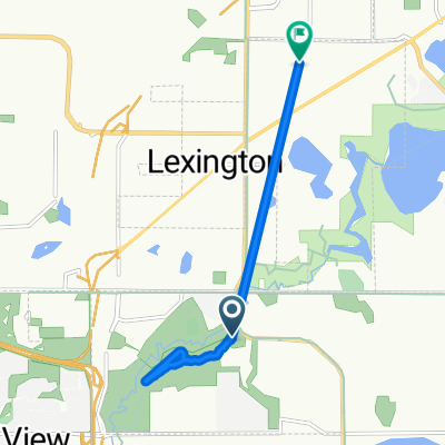
Shoreview to Village Bank (Blaine) via C.R. J
A cycling route starting in Lexington, Minnesota, United States.
Overview
About this route
This is my route to the Village Bank Financial Center on Highway 65. Most of the route is on paved bike paths with a bit of shared road time. The only tricky part is crossing Interstate 10 and rounding the curves on 93rd lane (it is only two lanes and can be busy). Lots of other bikers ride along CR J to get to the new Medtronic building.
- -:--
- Duration
- 9.2 km
- Distance
- 25 m
- Ascent
- 17 m
- Descent
- ---
- Avg. speed
- ---
- Max. altitude
Continue with Bikemap
Use, edit, or download this cycling route
You would like to ride Shoreview to Village Bank (Blaine) via C.R. J or customize it for your own trip? Here is what you can do with this Bikemap route:
Free features
- Save this route as favorite or in collections
- Copy & plan your own version of this route
- Sync your route with Garmin or Wahoo
Premium features
Free trial for 3 days, or one-time payment. More about Bikemap Premium.
- Navigate this route on iOS & Android
- Export a GPX / KML file of this route
- Create your custom printout (try it for free)
- Download this route for offline navigation
Discover more Premium features.
Get Bikemap PremiumFrom our community
Other popular routes starting in Lexington
 Route to Lexington Ave N, Blaine
- Distance
- 3.8 km
- Ascent
- 16 m
- Descent
- 16 m
- Location
- Lexington, Minnesota, United States
 Relaxed route in Shoreview
- Distance
- 6.6 km
- Ascent
- 13 m
- Descent
- 13 m
- Location
- Lexington, Minnesota, United States
 Shoreview to Village Bank (Blaine) via C.R. J
- Distance
- 9.2 km
- Ascent
- 25 m
- Descent
- 17 m
- Location
- Lexington, Minnesota, United States
 B2B00227 55014>55107 via Lexington, Como & Wabasha
- Distance
- 29.3 km
- Ascent
- 54 m
- Descent
- 89 m
- Location
- Lexington, Minnesota, United States
 B2B00254 55449>55403 via Long Lake Rd, Diagonal Trail, 6th Ave SE CLONED FROM ROUTE 46598
- Distance
- 28.3 km
- Ascent
- 80 m
- Descent
- 96 m
- Location
- Lexington, Minnesota, United States
 Shoreview
- Distance
- 12.9 km
- Ascent
- 37 m
- Descent
- 40 m
- Location
- Lexington, Minnesota, United States
 B2B00213 via Lexington Bike Path
- Distance
- 11.7 km
- Ascent
- 29 m
- Descent
- 27 m
- Location
- Lexington, Minnesota, United States
 B2B00254 55449>55403 via Long Lake Rd, Diagonal Trail, 6th Ave SE
- Distance
- 28.2 km
- Ascent
- 59 m
- Descent
- 84 m
- Location
- Lexington, Minnesota, United States
Open it in the app