

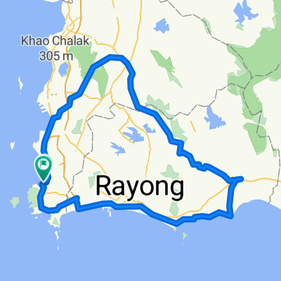
Moderate route in ตำบล สัตหีบ
A cycling route starting in Sattahip, Chon Buri, Thailand.
Overview
About this route
- 1 h 39 min
- Duration
- 7.6 km
- Distance
- 258 m
- Ascent
- 260 m
- Descent
- 4.6 km/h
- Avg. speed
- ---
- Max. altitude

Route photos


Route quality
Waytypes & surfaces along the route
Waytypes
Access road
6.1 km
(81 %)
Quiet road
1.4 km
(19 %)
Surfaces
Paved
0.2 km
(3 %)
Asphalt
0.2 km
(3 %)
Undefined
7.4 km
(97 %)
Continue with Bikemap
Use, edit, or download this cycling route
You would like to ride Moderate route in ตำบล สัตหีบ or customize it for your own trip? Here is what you can do with this Bikemap route:
Free features
- Save this route as favorite or in collections
- Copy & plan your own version of this route
- Sync your route with Garmin or Wahoo
Premium features
Free trial for 3 days, or one-time payment. More about Bikemap Premium.
- Navigate this route on iOS & Android
- Export a GPX / KML file of this route
- Create your custom printout (try it for free)
- Download this route for offline navigation
Discover more Premium features.
Get Bikemap PremiumFrom our community
Other popular routes starting in Sattahip
 Jour 75 – Sattahip - Nong Irun
- Distance
- 89.3 km
- Ascent
- 358 m
- Descent
- 318 m
- Location
- Sattahip, Chon Buri, Thailand
 Moderate route in ตำบล สัตหีบ
- Distance
- 7.6 km
- Ascent
- 258 m
- Descent
- 260 m
- Location
- Sattahip, Chon Buri, Thailand
 Recording from 4 เม.ย. 2560 17:47
- Distance
- 2.3 km
- Ascent
- 17 m
- Descent
- 14 m
- Location
- Sattahip, Chon Buri, Thailand
 Restful ride in ตำบล สัตหีบ
- Distance
- 4.4 km
- Ascent
- 54 m
- Descent
- 57 m
- Location
- Sattahip, Chon Buri, Thailand
 Easy ride in ไทย
- Distance
- 4.1 km
- Ascent
- 45 m
- Descent
- 60 m
- Location
- Sattahip, Chon Buri, Thailand
 300k loop
- Distance
- 302.7 km
- Ascent
- 287 m
- Descent
- 291 m
- Location
- Sattahip, Chon Buri, Thailand
 Short bike tour through สัตหีบ
- Distance
- 5.2 km
- Ascent
- 92 m
- Descent
- 94 m
- Location
- Sattahip, Chon Buri, Thailand
 Route from Soi Rungrueang, Amphoe Sattahip
- Distance
- 18.7 km
- Ascent
- 143 m
- Descent
- 145 m
- Location
- Sattahip, Chon Buri, Thailand
Open it in the app